


Bryce Canyon National Park is located in southern Utah on the eastern side of the Paunsaugunt Plateau in Garfield County. Settlement of the area began in 1874. Ebenezer Bryce moved from Pine Valley and settled a site near the mouth of Bryce Canyon in 1875. Bryce used the now famous canyon as a cattle range, and it was given his name as early as 1876. Despite the fragile nature of the environment, there are many miles of foot and horse trails below the rim. A twenty-mile paved highway runs along the edge of the rim. Bryce Canyon awaited promotion and development before its full tourism potential could be realized. National Forest Supervisor JW Humphrey was transferred from the La Sal National Forest to the Powell National Forest in July 1915. He was amazed at the beauty and grandeur of Bryce and resolved to do all he could to promote it and make it accessible. He took visiting dignitaries to Bryce and secured funds for a passable road to the canyon rim. In 1916 Arthur W Stevens of the Forest Service wrote an illustrated article for the Union Pacific railroad tourist magazine. JW Humphrey wrote a similar article for the Rio Grande railroad. These were the first descriptive articles published about Bryce Canyon. In the meantime, moving pictures and postcards began circulating and Bryce began to attract visitors from all parts of the nation. In 1919 the Utah state legislature asked Congress to create Bryce National Monument, which was done in 1923. The Union Pacific railroad acquired a state school section on the rim and began developing campgrounds, cabins, a lodge, and improved access to the Canyon. In 1928 Bryce Canyon was removed from Forest Service jurisdiction and made Bryce Canyon National Park. Later 12,000 additional acres were added to create what is now a 37,277 acre park that attracts hundreds of thousands of visitors each year from throughout the world to marvel at its unique beauty.
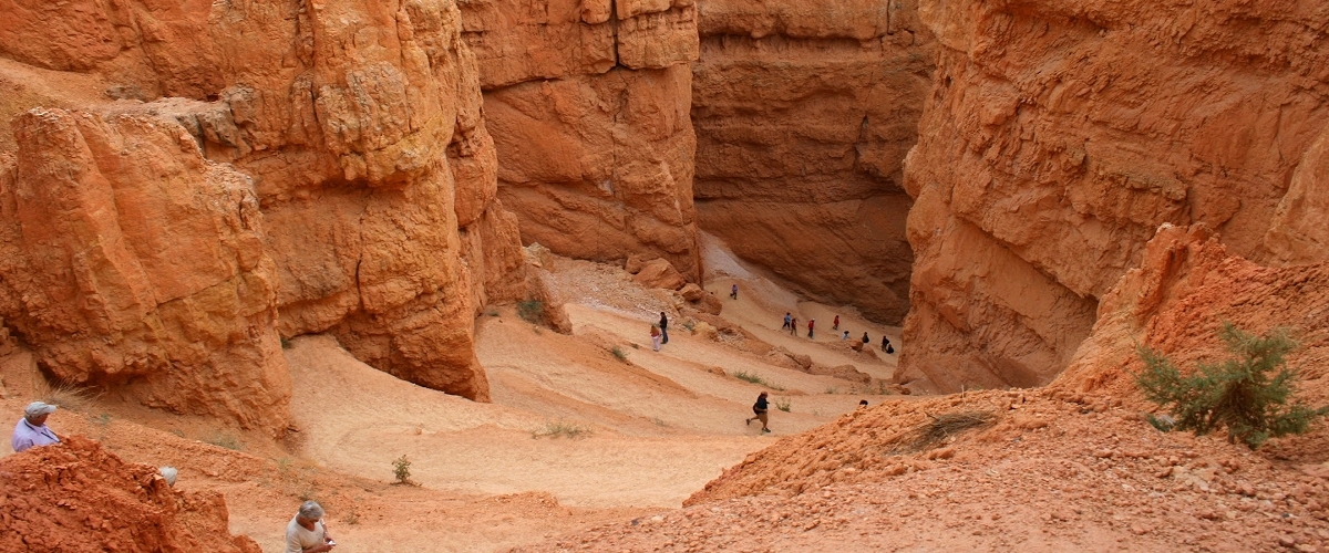
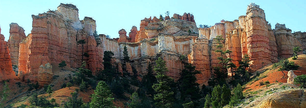
In Bryce Canyon, a geologic fairyland of rock spires rises beneath the high cliffs of the Paunsaugunt Plateau. This intricate maze, eroded from soft limestone, now glows with warm shades of red, orange, pink, yellow, and cream. The sun’s rays and cloud shadows moving across the landscape provide a continuous show of changing color. Bryce Canyon isn’t a canyon at all, but rather the largest of a series of massive amphitheaters cut into the Pink Cliffs. In Bryce Canyon National Park, you can gaze into the depths from viewpoints and trails on the plateau rim or hike down moderately steep trails and wind your way among the spires. A 17 mile scenic drive traces the length of the park and passes many overlooks and trailheads. Away from the road, the nearly 36,000 acres of Bryce Canyon National Park offer many opportunities to explore spectacular rock features, dense forests, and expansive meadows. The park’s elevation ranges 6,600 to 9,100 feet, so it’s usually much cooler here than at Utah’s other national parks. Expect pleasantly warm days in summer, frosty nights in spring and fall, and snow at almost any time of year. The visitors center, the scenic drive, and a campground stay open throughout the year.
The hike into Queen’s Garden is a good, relatively short hike, and it’s easy to fit into a one-day tour of the park. If you have more time to hike, the Navajo Loop Trail is also good. It can be combined with the Queen’s Garden for a pretty substantial trek. Another good bet for strong hikers is the outstanding Peekaboo Loop. These trails are often crowded near the rim, but less so the farther out you get. But if the crowds begin to get to you, it’s time to visit the Fairyland Loop Trail, which is less traveled. If you’re interested in photographing the hoodoos, and it’s hard to resist the urge, it makes sense to spend the night in or near the park. Photographers usually obtain the best results early and late in the day, when shadows set off the brightly colored rocks. Memorable sunsets and sunrises reward visitors who stay overnight. Moonlit nights reveal yet another spectacle. If you want to travel into the backcountry, be sure to consult with a ranger about your plans. Remember that winter can last a long time at this elevation, and many trails can be blocked by snow and ice into the spring. The weather can also take a toll on the trails, and it’s not uncommon to learn that your selected trail has been closed by a rockslide.
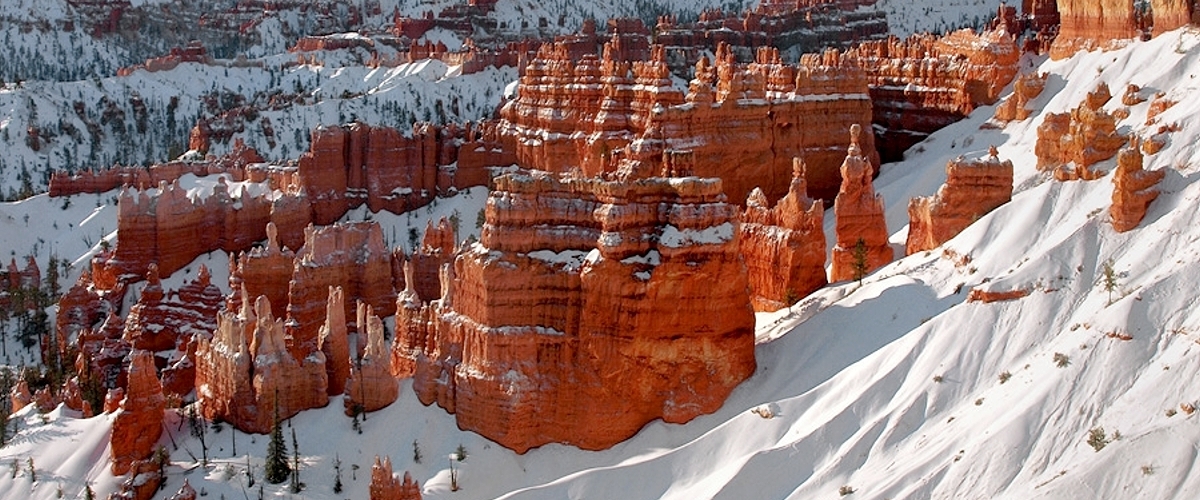
From elevations of about 8,000 feet near the visitors center, the park’s scenic drive gradually winds 1,100 feet higher to Rainbow Point. About midway you’ll notice a change in the trees from largely ponderosa pine to spruce, fir, and aspen. On a clear day you can enjoy vistas of more than 100 miles from many of the viewpoints. Visitors wishing to see all of the viewpoints from Fairyland Point to Bryce Point should take a walk on the 5.5-mile-long Rim Trail. Although many visitors assume that wind shaped Bryce Canyon’s hoodoos, they were, in fact, formed by water, ice, and gravity, and the way those elements and forces have interacted over the years on rocks of varying hardness. When the Colorado Plateau uplifted, vertical breaks called joints formed in the plateau. Joints allowed water to flow into the rock. As water flowed through these joints, erosion widened them into rivulets, gullies, and eventually deep slot canyons. Even more powerful than water, the action of ice freezing, melting, then freezing again, as it does about 200 days a year at Bryce, causes ice wedges to form within the rock joints, eventually breaking the rock. Bryce Canyon is composed of layers of limestone, siltstone, dolomite, and mudstone. Each rock type erodes at a different rate, carving the strange shapes of the hoodoos. Although Bryce is most popular during the summer months, it is especially beautiful and otherworldly during the winter, when the rock formations are topped with snow. Because Bryce is so high (elevation ranges 8,000 to 9,000 feet), winter lasts a long time, often into April. The main park roads and most viewpoints are plowed, and the Rim Trail is an excellent, easy snowshoe or cross-country ski route.
Bryce Canyon National Park is just south of the incredibly scenic Highway 12, between Bryce Junction and Tropic. To reach the park from Bryce Junction (7 miles south of Panguitch at the intersection of U.S. 89 and Hwy. 12), head 14 miles east on Highway 12, then south three miles on Highway 63. From Escalante, it’s about 50 miles west on Highway 12 to the turnoff for Bryce; turn south onto Highway 63 for the final three miles into the park (winter snows occasionally close this section). Both approaches have spectacular scenery. Free parking is available at the visitors center, outside the park entrance near shuttle bus stops. During the summer, Bryce hosts an enormous number of visitors. In order to keep the one main road along the rim from turning into a parking lot, the National Park Service runs the Bryce Canyon Shuttle every 15-20 minutes 8am-8pm daily mid-May thru mid-October. Buses run during the peak summer season from the shuttle parking and boarding area at the intersection of Highways 12 and 63 to the visitors center, with various stops. From the visitors center, the shuttle travels to the park’s developed areas, including all the main amphitheater viewpoints, Sunset Campground, and the Bryce Canyon Lodge. Passengers can take as long as they like at any viewpoint, then catch a later bus. The shuttle bus service also makes it easier for hikers, who don’t need to worry about car shuttles between trailheads.

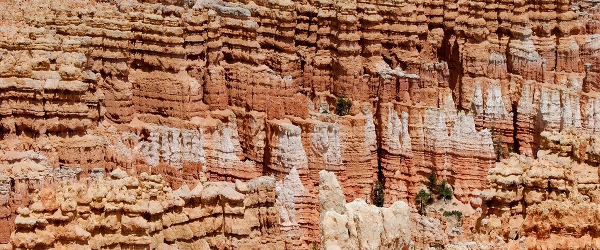
ENJOY THIS EXTENDED VIEW OF BRYCE CANYON NATIONAL PARK


Explore Utah was created and is maintained by Explore Utah Online ©2020-2026 (All Rights Reserved) This website was created for the enjoyment of Utah. If you believe copyrighted work is available on this website in a way that constitutes a copyright infringement please contact me for removal. All rights to the images and other materials used belong to their respective owners. I do not claim ownership over any third-party content used. Photos on this website are used for educational purposes only and used with permission and courtesy of: Scott Taylor - Albert Wirtz - Angela Banfield - Catherine Colella - Chase Bartholomew - Danielle Yung - Elliott Hammer - Francisco Ovies - George Gibbs - Greg Kebbekus - Hilary Bralove - Jacob Moogberg - Jim Paton - Jim and Nina Pollock - John Dahlstet - Jay Luber - Jessica Holdaway - John Hammond - John Dahlstet - Logan Selinski - Logan Selinski - Michelle Leale - Mae Thamer - Mark Thompson - Mia & Steve Mestdagh - Michelle Leale - Randy Baumhover - Sven Hähle - Shawn Anthony - Thomas Eckhardt - Thomas Jundt - University Of Utah - Bureau of Land Management - Utah Education Network - Utah History Encyclopedia - Utah League of Cities and Towns - Utah Geological Survey - Ski Utah - Free To Use Photo Websites: Unsplash - Pexels - Freepik - Pixabay - iStock - ShutterStock - Burst - Flickr - PickPik - Rawpixel - HistoryPictureArchive This website contain links to third party websites. The linked sites are not under the control of this website and is not responsible for the contents of any linked website. These links are provided as a convenience only and shall not be construed as an endorsement of, sponsorship of, or affiliated with the linked website ... Send your comments or questions to webmaster@exploreutah.online