


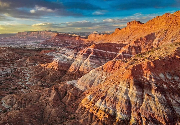
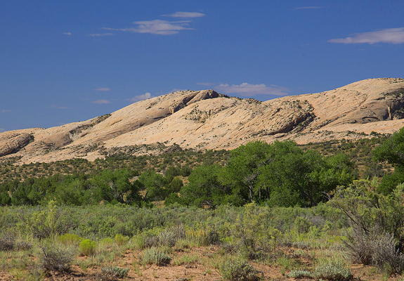
This magical landscape known as the Grand Staircase Escalante National Monument is situated in South Central Utah and runs into North Central Arizona and is over 2 million acres of wildly beautiful and historically significant land. You could spend a lifetime here and still have so much left to explore and discover. It is not only a geologist’s dream, but an adventurer’s playground and an excitement to photographers. A place worth visiting over and over again, and undoubtedly a place worth protecting.
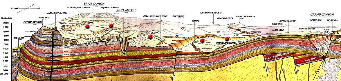
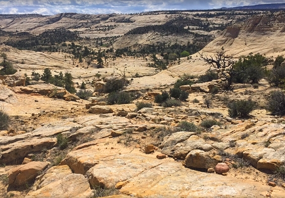
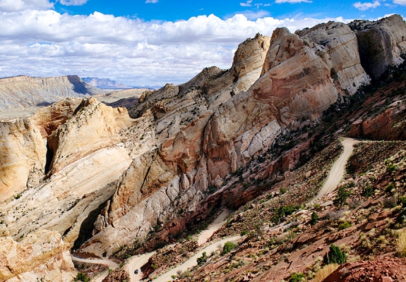
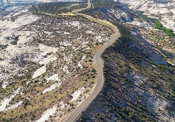
The Staircase is not an actual physical staircase. It is rather an incredibly unique geologic formation. A series of stepped plateaus identified by the main color of the rock. The Grand Staircase Escalante National Monument is one that you have to see for yourself to understand its vastness and unending treasures. Grand Staircase Escalante National Monument is a phenomenal landscape that is difficult to describe in words because it leaves you speechless with its beauty. A Sun-drenched Utah backcountry spreads out well beyond the visible horizon from the road. The Grand Staircase area is more remote and less visited. It is spectacular and contains the most extensive network of slot canyons in Utah. It is surrounded by National Parks, National Recreation Areas and National Monuments that is part of the Grand Staircase. To the north is Bryce Canyon and Capitol Reef, to the southeast is Glen Canyon, to the west is Zion National Park, and it stretches into Arizona to the Grand Canyon.
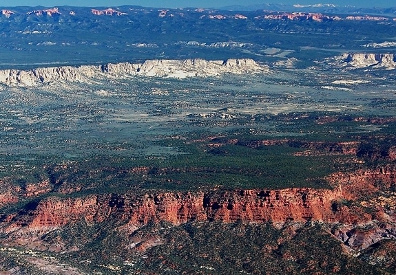
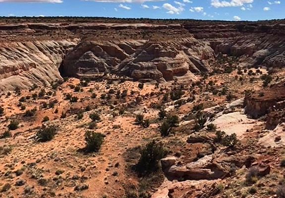
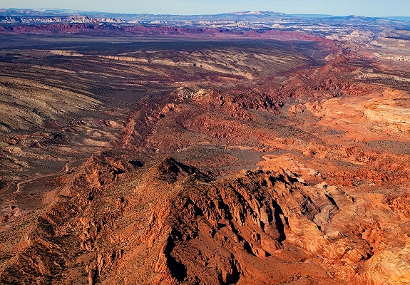
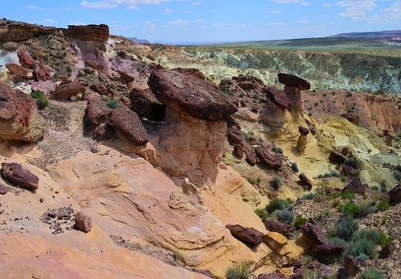
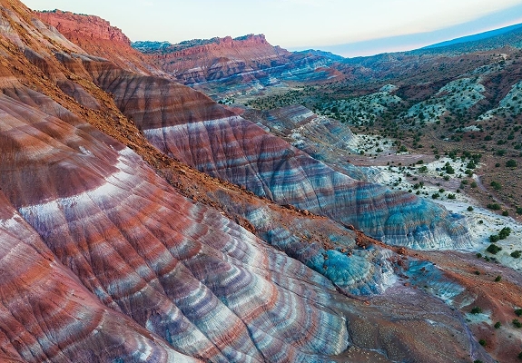
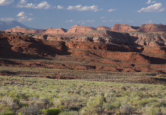
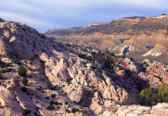
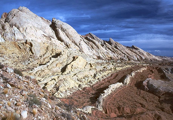
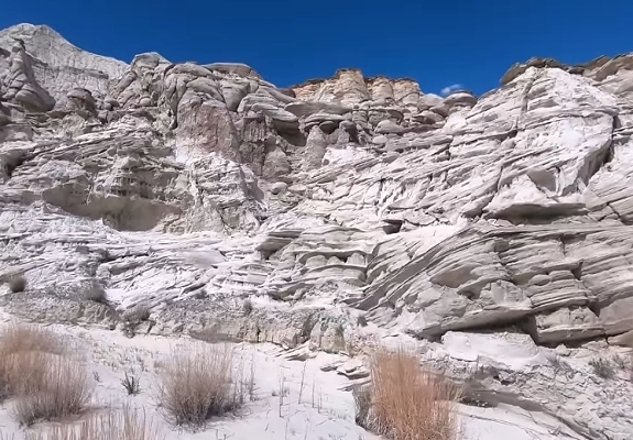
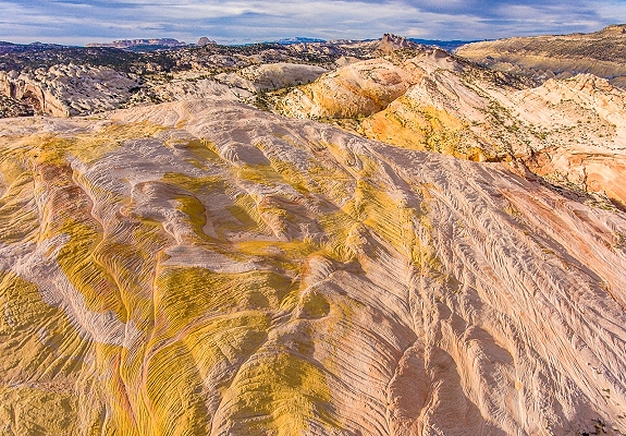
The monument contains many diverse landscapes including the Paria Plateau, Kaiparowits Plateau, Vermilion Cliffs, Pink Cliffs, Gray Cliffs, White Cliffs, Coyote Buttes, Buckskin Mountains & Gulch, Smoky Mountain, The Cockscomb, Fiftymile Mountain & Bench, Straight Cliffs, Kodachrome Basin, The Wave, White Pocket and Paria Mountains & several River Canyons. These sedimentary rocks have been deeply eroded for millions of years, exposing hundreds of layers of richly colored rock strata. Mesas, buttes, hoodoos and large tablelands are interspersed with steep canyons. The soft entrada sandstone bedrock here is variously grey, light brown, very pale green or pure white in color and forms hoodoos ranging in shape from broad and short to tall, slender and tapering, topped either by dark sandstone blocks or unusual boulders of purple, composed of small pebbles bonded together.
Please keep checking back as new content is added, expanded and updated!
Click Below To Learn More And Join

The monument stretches from the towns of Escalante, Boulder, Tropic, Big Water, Kanab, in Utah down to Page and Freedonia in Arizona. Geologically speaking, the Grand Staircase of the Escalante is a continuous succession of old to young sedimentary rock layers. The Grand Staircase is comprised of all rocks from the bottom of the Grand Canyon (2,400 feet) to the top of Bryce Canyon (10,000 feet).

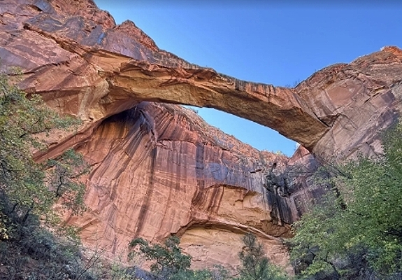
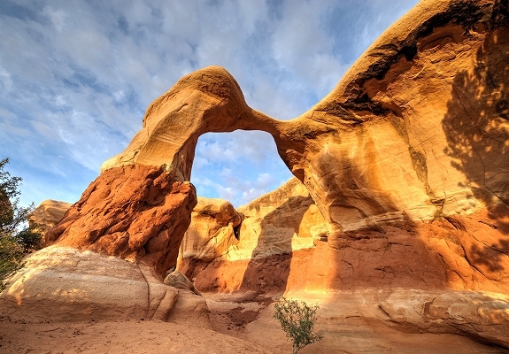
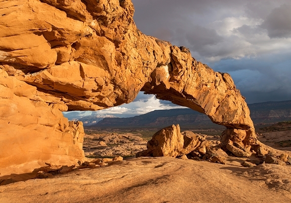
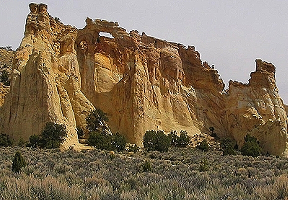
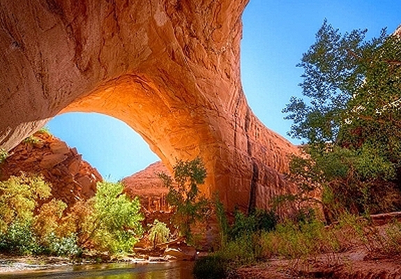
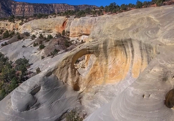
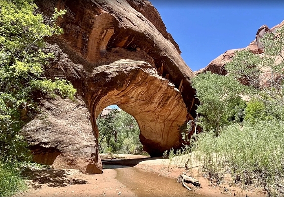
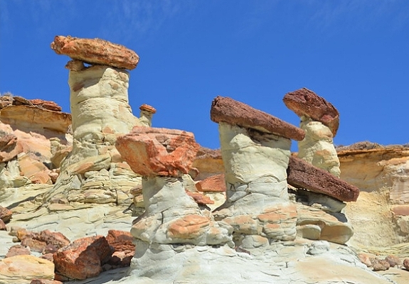
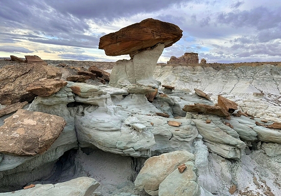
Did you know that the Grand Staircase-Escalante National Monument is home to 2,517 natural stone arches? That’s 517 more than Arches National Park! Over time salt beds was covered with sediments that eventually compressed into rock layers of Sandstone. Rock layers surrounding the edge of the salt beds continued to erode and shift into vertical sandstone walls called fins. Sand collected between vertical walls of the fins then slightly acidic rain combined with carbon dioxide in the air allowed for the chemical formation of carbonic acid within the trapped sand. Over time, the carbonic acid dissolved the calcium carbonate that held the sandstone together. Many of the rock formations have weaker layers of rock on bottom that are holding stronger layers on top. The weaker layers would dissolve first, creating openings in the rock. Gravity caused pieces of the stronger rock layer to fall piece by piece into an arch shape. Arches form within rock fins at points of intense fracturing localization or weak points in the rock's formation caused by horizontal and vertical discontinuities. Lastly water, wind, and time continued this erosion process and ultimately created the arches.

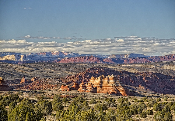
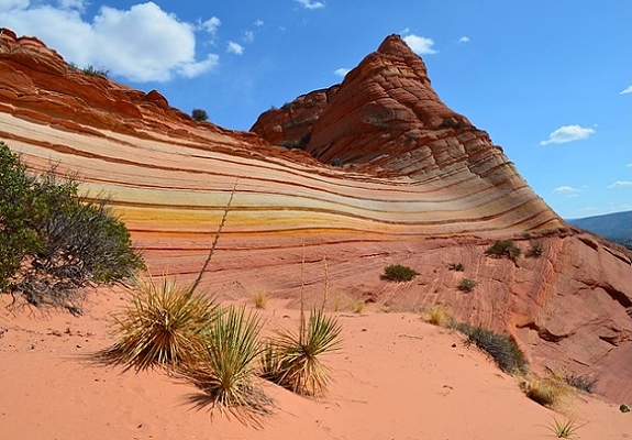
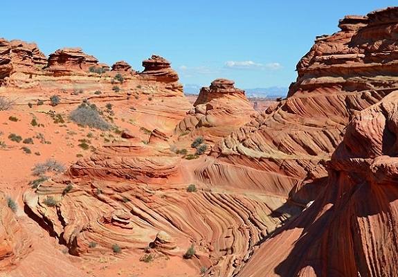
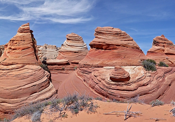
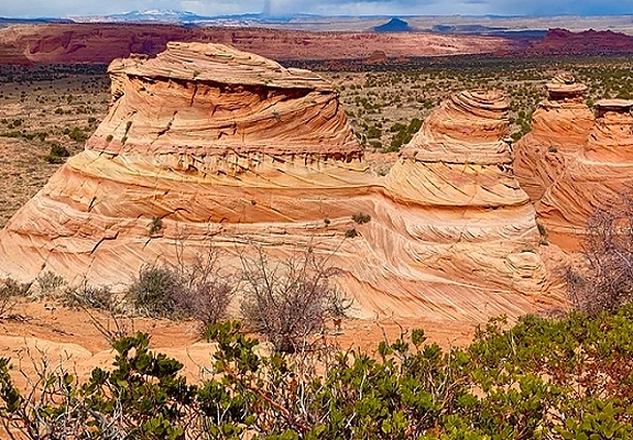
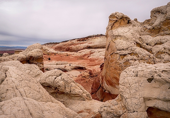
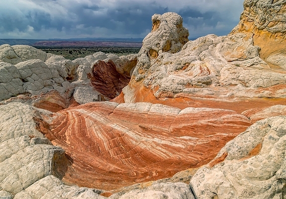
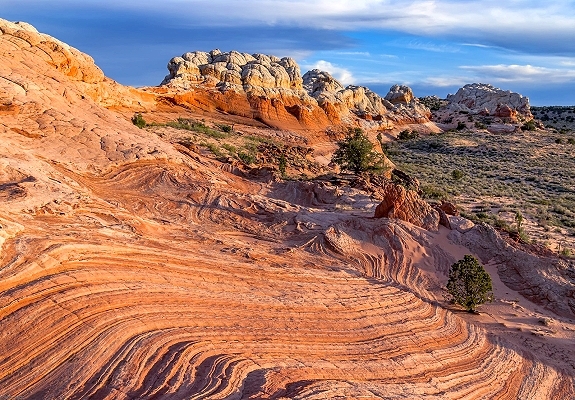
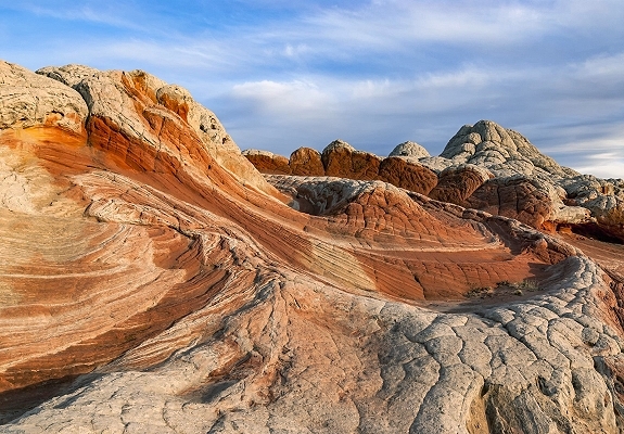
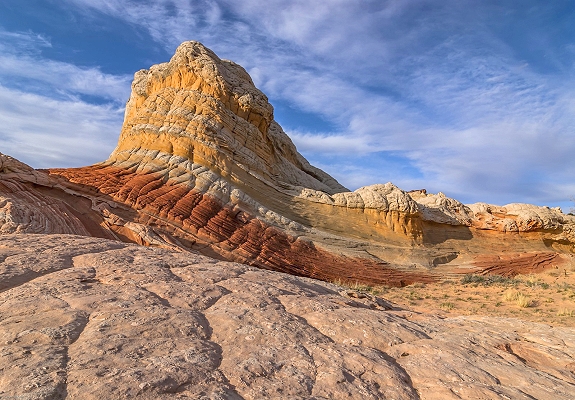
Cottonwood Cove is a scenic remote area within the Coyote Buttes South unit of the Paria Canyon-Vermilion Cliffs Wilderness, part of the larger Grand Staircase-Escalante National Monument region. The area known for its colorful sculpted sandstone fins and formations. The rock fins are made of Navajo Sandstone sculpted by millions of years of wind and water erosion creating unique patterns and formations of crumbling fins of angled rock strata.
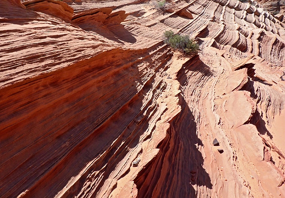

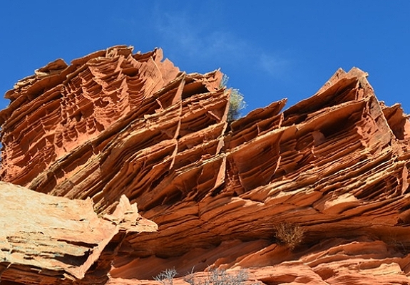
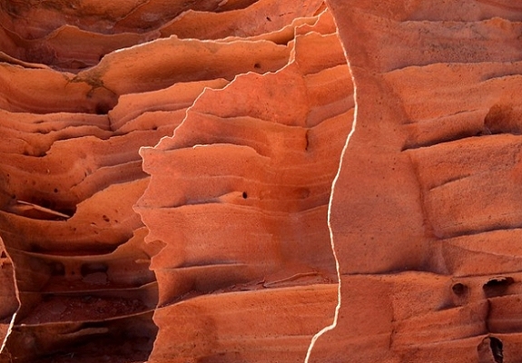

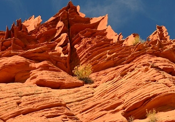
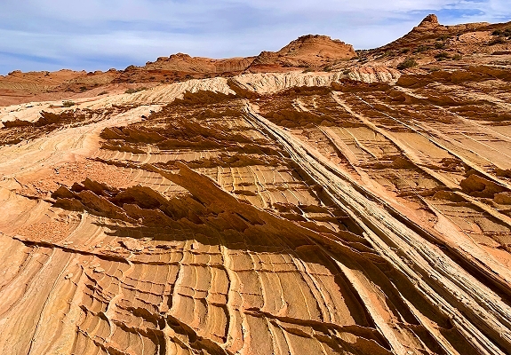
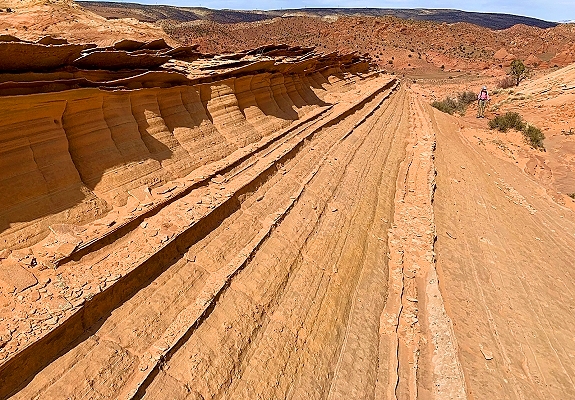
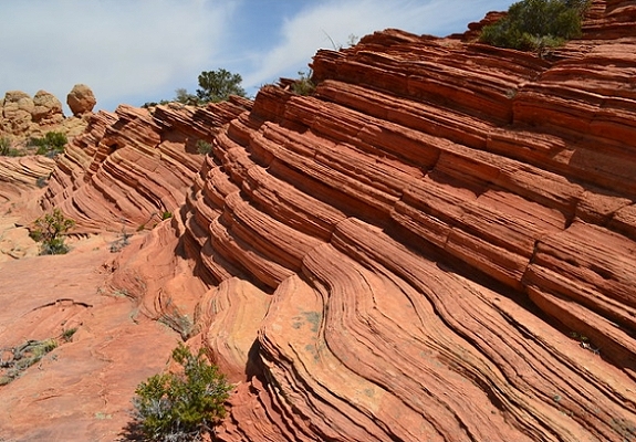

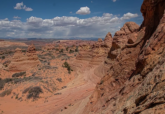
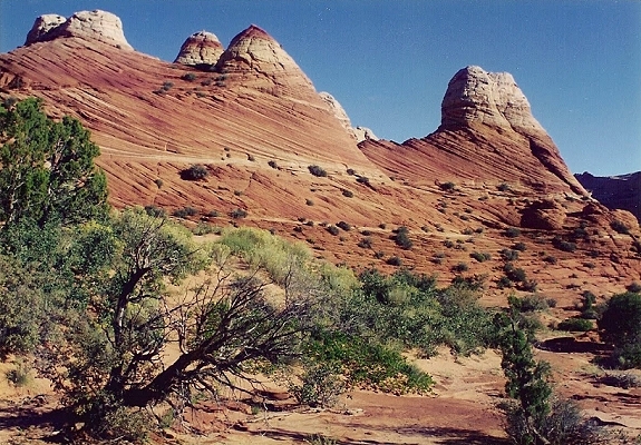
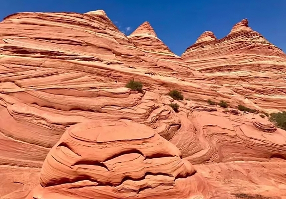
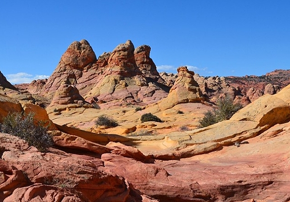
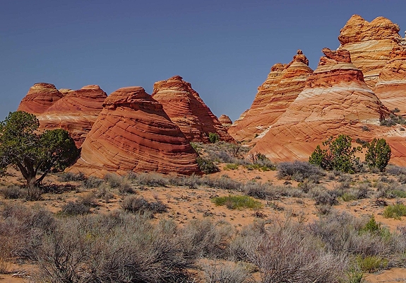
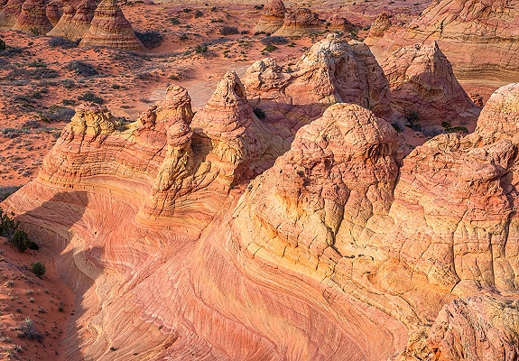
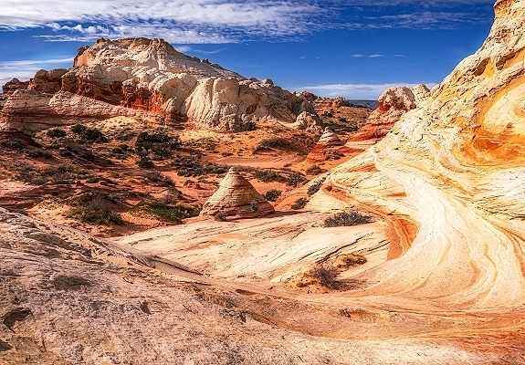
The Coyote Buttes are a remote rugged area renowned for having some of the world's most unique and visually stunning geologic sandstone formations. The area is part of the larger Paria Canyon-Vermilion Cliffs Wilderness which spans the border of extreme south-central Utah and north-central Arizona and sits at the southern edge of the Grand Staircase-Escalante National Monument. The region is an exposure of Navajo Sandstone with vibrant swirling colors resulting from various iron oxide pigments in the layers. However Coyote Buttes is not a single location but rather a region with two distinct areas: North and South. The Coyote Buttes area is an exposure of cross-bedded aeolian Jurassic Navajo Sandstone. The area includes dramatic swirling erosional rock formations such as The Wave, sandstone arches, Cottonwood Cove, hoodoos and sandstone teepees which are in their own sections on this page.

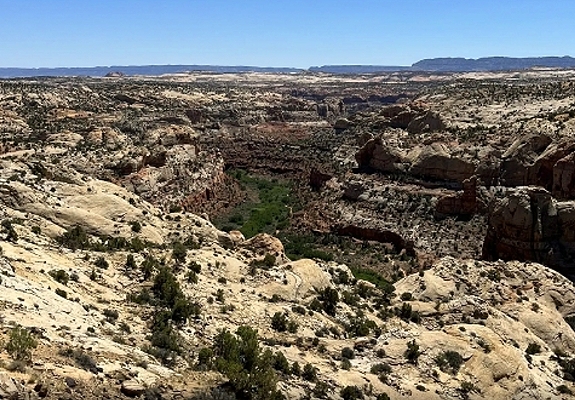
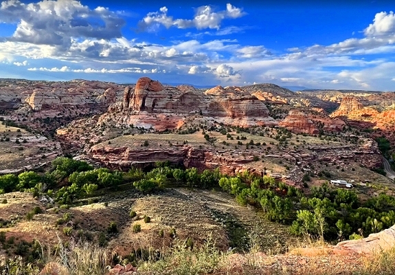
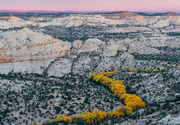
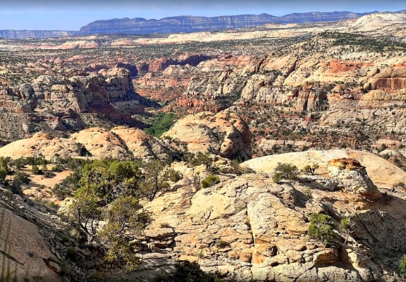
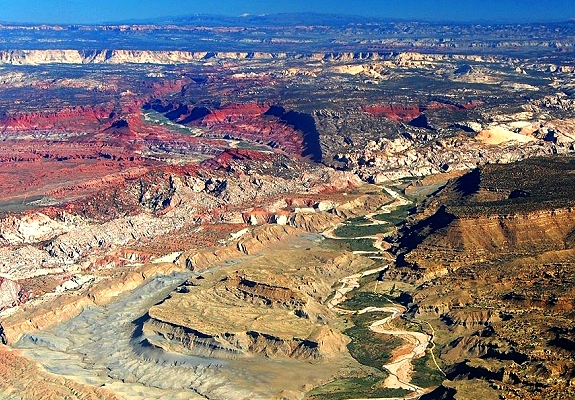
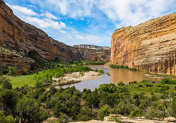
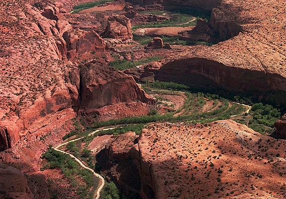
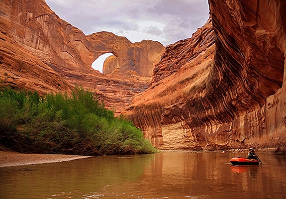
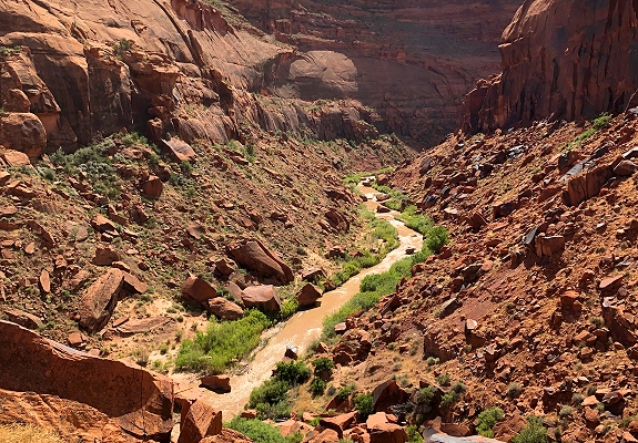
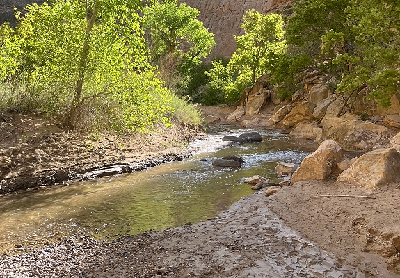
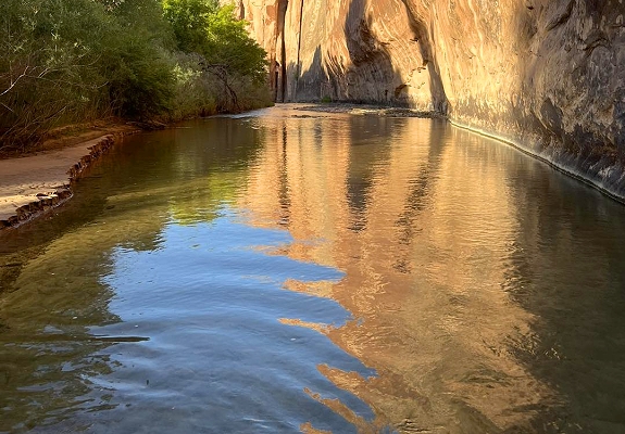
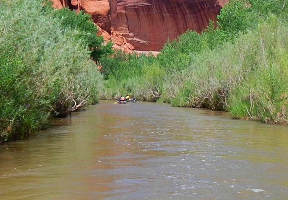
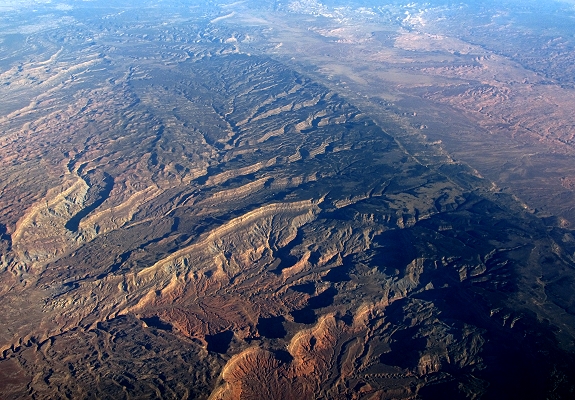
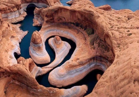
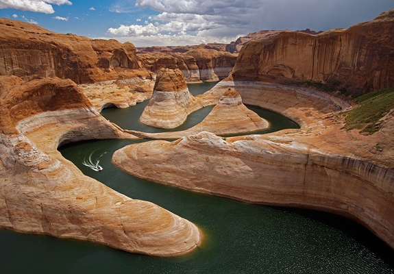
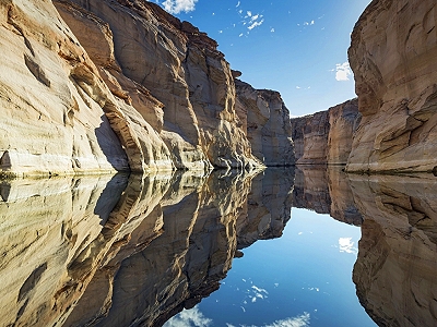
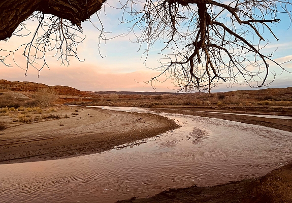
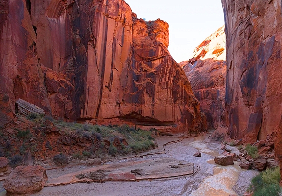
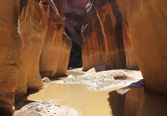
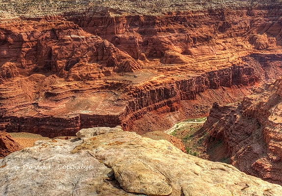
The Escalante River and Canyon system is a vast intricate network of canyons in southern Utah renowned for its remote wilderness, spectacular scenery, and unique geology. It is a core section of the Grand Staircase-Escalante National Monument and also flows into the Glen Canyon National Recreation Area. Remote and Rugged: The Escalante River was one of the last sizable rivers to be formally mapped in the contiguous United States, a testament to the isolation and challenging nature of its terrain. The region lacks development requiring visitors to be self sufficient and prepared for backcountry conditions. Geological Wonderland: The river and its numerous perennial and ephemeral tributaries have carved an extensive labyrinthine system into thick layers of Mesozoic sandstone primarily the Navajo and Wingate formations. This erosion has created a landscape filled with arches, natural bridges, slot canyons, waterpockets, and towering cliffs with desert varnish. Oasis in the Desert: Despite the arid high-desert climate the river supports a lush riparian ecosystem of cottonwood trees, willows, and other plants that provide critical habitat for birds, mammals, and other wildlife, offering a stark contrast to the surrounding slickrock landscape. Variable Water Flow: The river's flow is highly dependent on snowpack and flash floods with peak flow typically occurring in the late spring or early summer for a short unpredictable window. In the Grand Staircase–Escalante National Monument the Escalante River has cut deep into the sandstone over many millennia to create a tangle of interconnected sometimes quite narrow steep-sided canyons that provide a challenge for hikers. Native trees dominate the Escalante River, one of the last free flowing tributaries of the Colorado River. While a thousand people live in the Escalante River watershed, millions of visitors come here to play, recreate and enjoy this stunning ribbon of green in a vast slickrock wilderness.


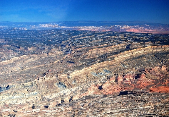
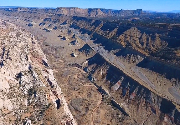
Fiftymile Mountain is a prominent isolated plateau and associated wilderness study area located in a remote part of southern Utah primarily within the Grand Staircase-Escalante National Monument and adjacent to the Glen Canyon National Recreation Area. It is a vast high-elevation island of green amidst the surrounding red and yellow desert canyonlands. Location: Situated in the central part of the Grand Staircase-Escalante National Monument in Kane County the area lies between the rugged Straight Cliffs to the east and a network of deep canyons draining southwest to Lake Powell. Geology: The mountain is a significant feature of the Colorado Plateau formed from a thick sequence of sedimentary rocks. The dramatic Straight Cliffs form the eastern edge of the plateau and can be nearly 2,000 feet high. Vegetation and Wildlife: Due to the changes in elevation the region hosts diverse ecosystems ranging from desert shrubs and grasses in the canyons to pinyon-juniper woodlands and stands of aspen at higher elevations. This environment supports a variety of wildlife including mule deer, elk, mountain lions, and numerous bird species. Views: Fiftymile Mountain is particularly known for its expansive panoramic views of the lower Glen Canyon region, Lake Powell, and the distant Navajo Mountain. Straight Cliffs: a prominent long line of nearly rectilinear cliffs in south-central Utah that define the eastern edge of the vast Kaiparowits Plateau and the topographic feature known as Fiftymile Mountain.
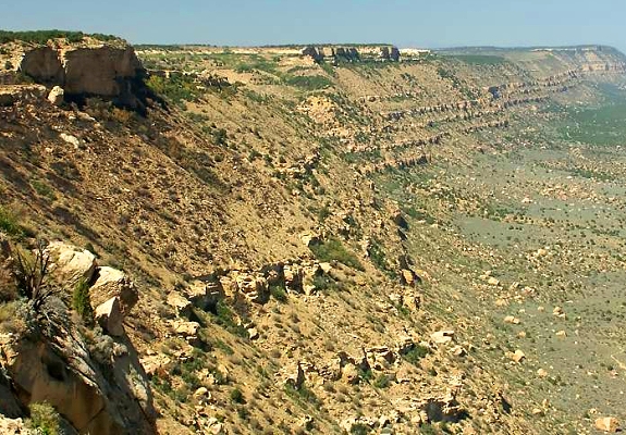
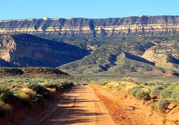
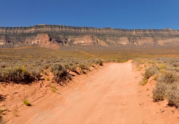
This significant geological feature is a core component of the Grand Staircase-Escalante National Monument. The cliffs are a sheer imposing wall of rock that stretches for about 60 miles and can reach nearly 2,000 feet in height in some areas. The various layers within the formation are distinct. The cliff-forming units are generally yellowish-gray to buff-brown massive sandstones. The intervening slope-forming units are a mix of finer-grained rocks that are often covered by debris. A distinctive Calico Bed at the top of of the formation is noted for its white and orange coloring. The area surrounding the Straight Cliffs is remote and rugged. Its extension to the southeast, Fiftymile Mountain runs nearly to the Colorado River and Lake Powell and is a prominent part of the northern skyline from the Glen Canyon National Recreation Area. The Kaiparowits Plateau extends for over 50 miles from near the town of Escalante in Garfield County to the south and southwest through Kane County and nearly to the border with Arizona.


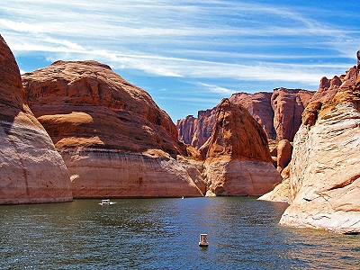
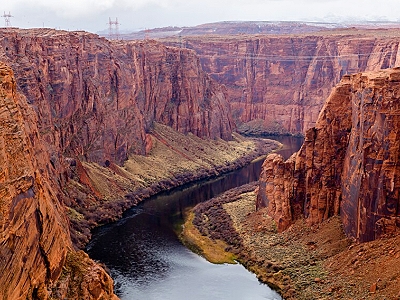
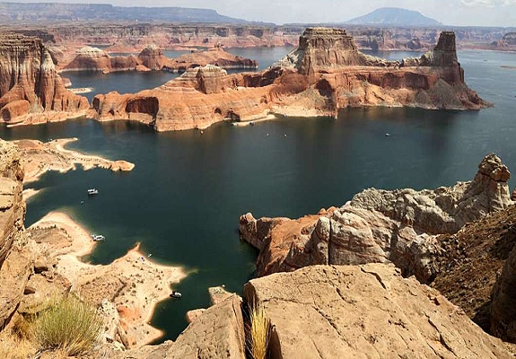
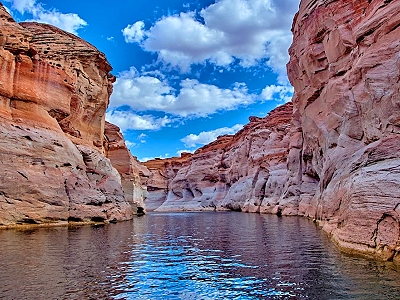
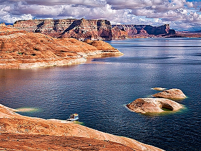
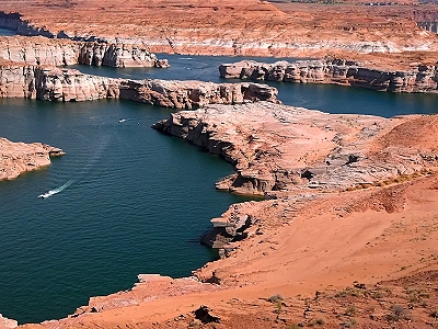
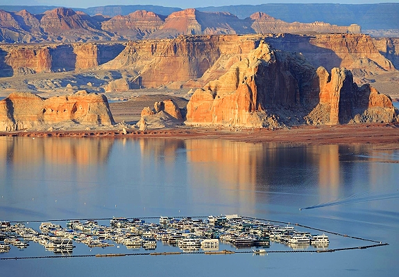
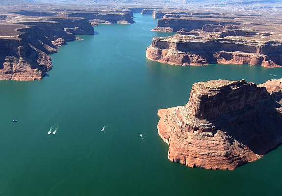
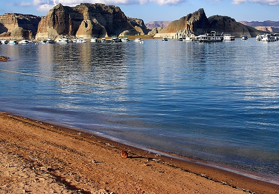
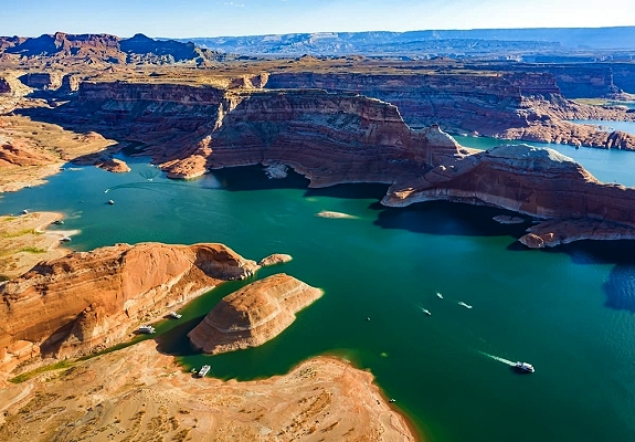
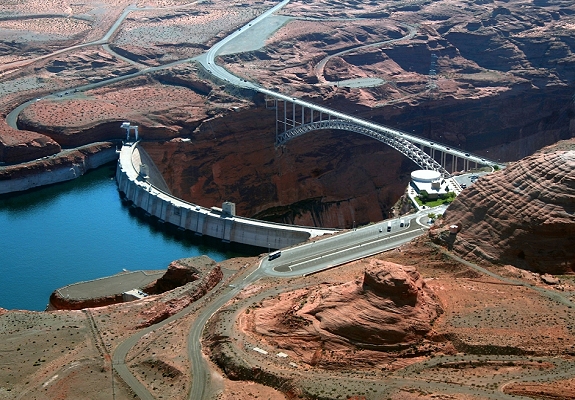
Glen Canyon is a stunning landscape of deep sandstone gorges carved by the Colorado River and Lake Powell is the vast man-made reservoir that now fills the majority of those canyons straddling the border of northern Arizona and southern Utah. The entire area is managed by the National Park Service as the Glen Canyon National Recreation Area. Glen Canyon: Before the construction of the Glen Canyon Dam the canyon was a remote wilderness known for its intricate rock formations, natural arches, and rich cultural history including ancient Native American sites. Today while much of the original canyon is submerged the remaining exposed areas and the surrounding landscape still feature dramatic red rock cliffs, mesas, and numerous side canyons that attract hikers and photographers. A short section of the original river still flows below the dam to Lees Ferry. Lake Powell: The lake was created by the completion of the Glen Canyon Dam which transformed the desert canyon into the second largest artificial reservoir in the United States by maximum water capacity. Scenic Contrast: The lake is famous for its striking visual contrast: deep blue water set against towering, colorful red and yellow sandstone cliffs. Massive Shoreline: The lake stretches for approximately 186 miles and when full has nearly 2,000 miles of shoreline, longer than the entire U.S. West Coast. This extensive shoreline creates countless secluded coves and sandy beaches, making it ideal for houseboating and camping. Purpose: The dam and lake were built to provide water storage for the arid southwestern states and to generate hydroelectric power.
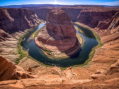
Glen Canyon offers unparalleled opportunities for both water-based and backcountry recreation. Water Activities: Boating, houseboating, kayaking, fishing, swimming, and water sports are the main draw for millions of visitors each year. Land Activities: Hiking, off-road vehicle driving, and scenic drives are also popular. The area has a few developed trails, but much of the exploration is backcountry. Notable Destinations: Popular nearby attractions accessible from the area include: Rainbow Bridge National Monument: One of the world's largest natural bridges reachable by boat or a long hike. Antelope Canyon: A world-famous slot canyon on Navajo Nation land accessible via guided tours from the nearby town of Page Arizona. Horseshoe Bend: A dramatic overlook of the Colorado River near Page Arizona. Glen Canyon starts where Narrow Canyon ends at the confluence of the Colorado River and the Dirty Devil River. Like the Grand Canyon farther downstream, Glen Canyon is part of the immense system of canyons carved by the Colorado River and its tributaries.

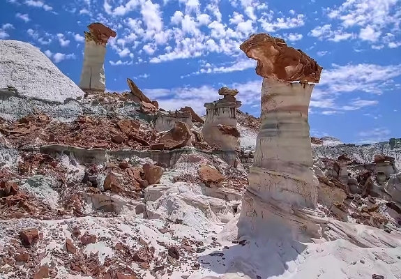
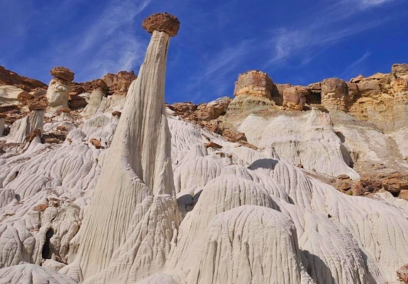
Hoodoo rock formations (also called a tent rocks or fairy chimneys) are iconic geological features of southern Utah's desert landscape most famously found in Bryce Canyon National Park which hosts the largest concentration of them in the world. They are tall thin spires of rock that resemble totem poles and are sculpted by a combination of weathering and erosion. Hoodoos form through a process of differential erosion acting on specific layered sedimentary rocks typically over millions of years. The recipe for a hoodoo involves three main steps. Deposition: Layers of soft sedimentary rock like mudstone and siltstone are deposited often in an ancient lake or floodplain system and covered by a harder more resistant layer of rock like well-cemented sandstone or limestone. Uplift: Tectonic forces then uplift the entire region to a high elevation exposing the rock layers to the elements. Erosion: This is the sculpting phase. Frost Wedging: Water seeps into cracks in the rock. In areas with frequent freeze-thaw cycles (common in southern Utah's high plateaus) the water freezes and expands acting as a wedge to break the rock apart and widen cracks. Chemical Weathering: Slightly acidic rainwater slowly dissolves the calcium carbonate cement that holds the softer layers together rounding the edges and leaving a totem pole shape. Differential Erosion: The hard capstone at the top protects the softer pillar of rock beneath it from eroding as quickly as the surrounding material resulting in the distinctive spire shape. Eventually ongoing erosion will cause the hoodoo to collapse under its own weight and the process of new hoodoo formation begins elsewhere ensuring the landscape is constantly changing.
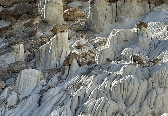

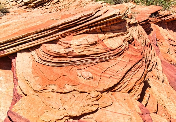
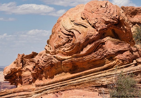
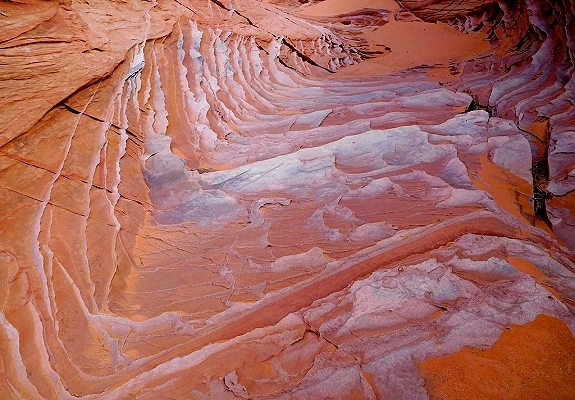
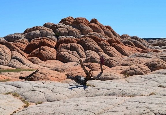
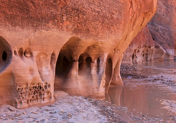
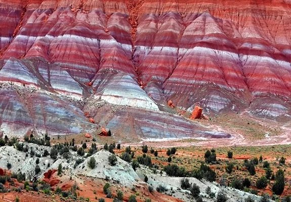
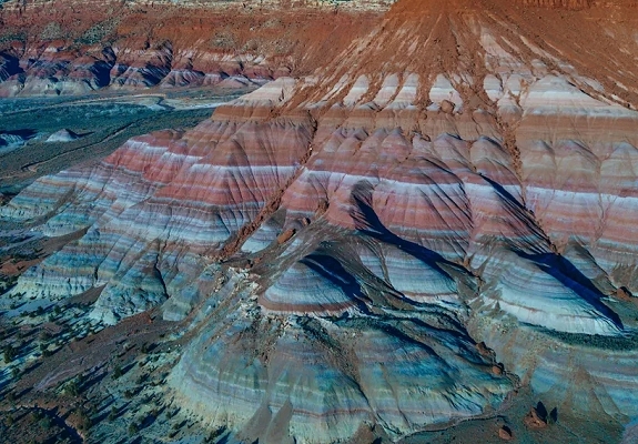
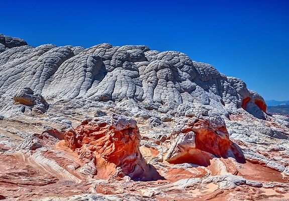
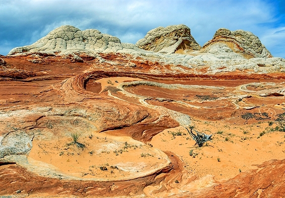
Middle Reservoir brain rocks refers to a specific lesser-known collection of unique sandstone formations on the remote Paria Plateau in northern Arizona part of the Vermilion Cliffs National Monument. This area features the same brain rock or cauliflower rock formations found at the more famous White Pocket and Coyote Buttes locations. Geological Description: The formations are primarily composed of Navajo Sandstone that originated from vast ancient desert sand dunes. Appearance: The rocks are characterized by their unusual undulating surfaces that resemble a human brain or a head of cauliflower. They feature a unique white or gray top layer above red and orange sandstone layers creating a vibrant contrast. The surface is split by deep irregular polygonal cracks. Formation Theories: The exact geological process behind the brain rock texture is still debated by experts. A leading theory is soft sediment deformation suggesting that the contortions and twists occurred when the sand was saturated with water and before it was fully compressed into solid rock. The hard white caprock then protected the softer contorted rock underneath from later wind and water erosion preserving the bizarre shapes. Middle Reservoir is an extremely remote backcountry location accessible only by high-clearance true 4-wheel-drive vehicles due to deep sand and challenging dirt roads across the Paria Plateau.

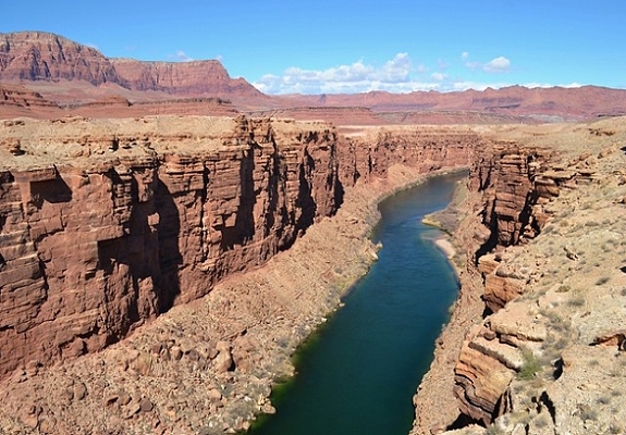
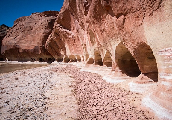
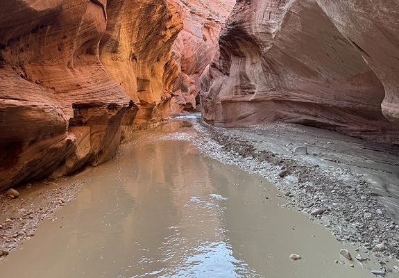
The Paria River and Canyon is a spectacular and remote wilderness area on the border of southern Utah and northern Arizona renowned for having some of the most beautiful and extensive canyon systems on the Colorado Plateau. The Paria River is a 95-mile-long tributary of the Colorado River that flows southeast from its headwaters in the Grand Staircase-Escalante National Monument to its confluence with the Colorado River at Lees Ferry just below the Glen Canyon Dam and the start of the Grand Canyon. Muddy Water: The name Paria is a Paiute word often translated as muddy water. The river is indeed known for its extremely high sediment concentration which gives it a distinctive coffee color and plays a vital role in carrying sediment to the Colorado River system. Variable Flow: The river's flow is highly seasonal and dependent on snowmelt and monsoonal rains. It can be a shallow walkable stream most of the year but is prone to dangerous and powerful flash floods after heavy rains which can cause the water to rise by many feet in minutes. The canyon carved by the river is a stunning example of water erosion through thick layers of colorful sandstone exposing millions of years of geological history in swirling bands of red, orange, pink, and white. Towering Walls: The canyon features sheer towering walls often streaked with dark desert varnish, huge amphitheaters, and occasional hanging gardens. Buckskin Gulch: The Paria Canyon system includes Buckskin Gulch, a major tributary considered one of the longest and deepest slot canyons in the United States which narrows to only a few feet wide in places. The Paria River and Canyon offer world-class wilderness backpacking and day hiking experiences.

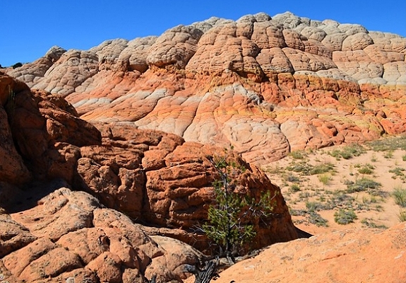
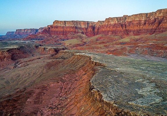
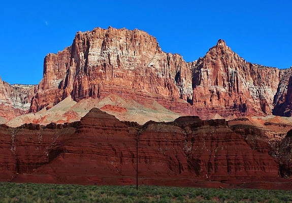
The Paria Sand Hills and Cliffs, more formally recognized as the Paria Canyon-Vermilion Cliffs Wilderness and the Paria Plateau are a stunning geological region spanning the border of southern Utah and northern Arizona. The area is known for its breathtaking red rock landscapes, deep canyons, and unique sandstone formations. The Cliffs: The most dominant feature is the Vermilion Cliffs a spectacular 3,000-foot escarpment of Navajo sandstone that rises dramatically from the surrounding desert floor. Coloration: The name comes from the vivid red, orange, and white hues of the rock layers which are caused by various mineral pigments primarily iron oxides. Geology: These layers of sandstone, siltstone, and shale were deposited over millions of years when the region was a mix of ancient deserts, rivers, and shallow seas. Erosion has since exposed these ancient layers. Location: The cliffs run along the southern edge of the Paria Plateau extending into Arizona and are a core part of the larger Grand Staircase geological formation. The Sand Hills: The Paria Plateau and Sand Formations are part of the vast remote Paria Plateau and surrounding areas including the famous Coyote Buttes sections. Sand Dunes: The area features shifting fields of sand dunes that get their color from the eroding red sandstone. The nearby Coral Pink Sand Dunes State Park is a prime example of this phenomenon where wind funnels through a geologic notch to deposit sand in a vibrant coral color. Unique Formations: The most iconic sand hills are the swirling undulating sandstone formations in the Coyote Buttes area. These look like frozen flowing waves of rock and are highly sought after by photographers.

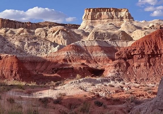
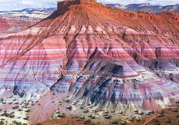
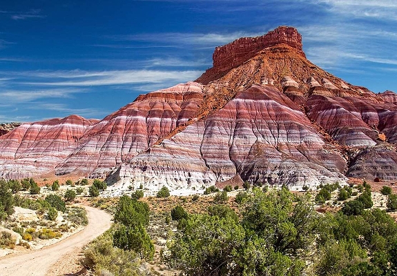

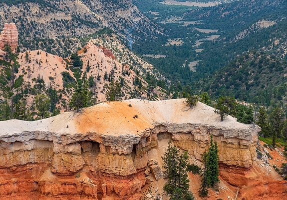
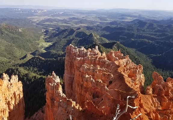
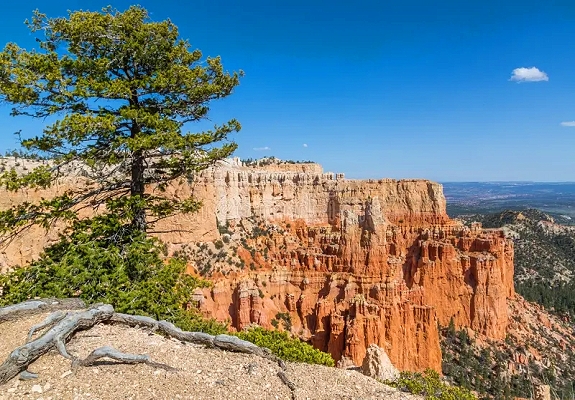
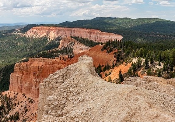
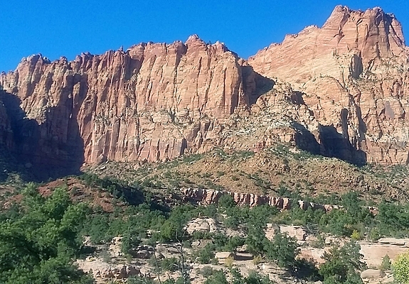
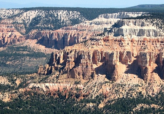
The Pink Cliffs are a prominent and extensive geological feature in southwestern Utah known for their stunning colors and intricate rock formations. They form the highest and youngest step in the five-step Grand Staircase, a vast sequence of rock layers stretching from the Grand Canyon in Arizona to the high plateaus of Utah. Key Characteristics: Geology and Composition: The Pink Cliffs are composed primarily of the Claron Formation which is made of pink, white, and red limestone, with some interbedded sandstone and shale. These sediments were deposited in a large system of lakes and floodplains approximately 30 to 60 million years ago after the age of the dinosaurs. Coloration: The vibrant pink, red, and orange hues are caused by the oxidation (rusting) of small amounts of iron minerals within the limestone. Manganese oxides also contribute to occasional blue or purple tints. The colors change intensity with passing light and weather conditions. Formations: The most famous features of the Pink Cliffs are the countless hoodoos (tall, irregular spires of rock) created by frost wedging and differential erosion. The softer limestone erodes more easily leaving behind the spire shape often capped by a harder protective rock layer. While the Pink Cliffs extend well beyond a single park the most popular and accessible areas to view them are within national park service lands. Bryce Canyon National Park: This park contains the world's largest concentration of hoodoos and is the premier location to see the spectacular deeply eroded amphitheaters of the Pink Cliffs. The rim road offers numerous viewpoints like Sunset and Sunrise Points. Cedar Breaks National Monument: Located at the western edge of the Markagunt Plateau, this features its own massive amphitheater filled with vibrant pink-hued hoodoos and formations. Dixie National Forest: Large sections of the Pink Cliffs and the surrounding plateaus are within the Dixie National Forest offering additional opportunities for scenic drives and hiking in less crowded areas.

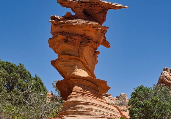
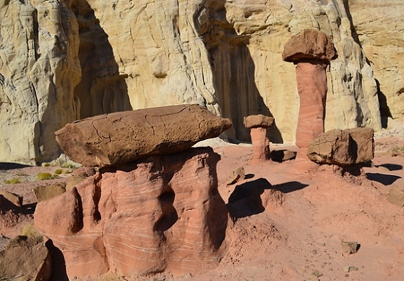
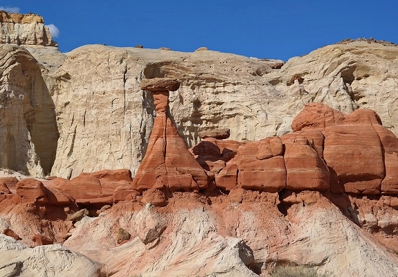
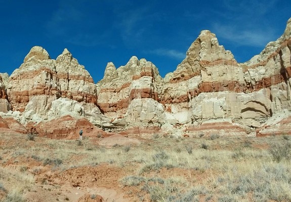
Sandstone Teepees are a unique and visually striking type of conical rock formation found in specific remote regions along the Utah-Arizona border. These formations get their name from their resemblance to Native American teepee dwellings. The primary location for viewing these remarkable formations is within the South Coyote Buttes section of the Paria Canyon-Vermilion Cliffs Wilderness, part of the Grand Staircase-Escalante National Monument region. Cottonwood Cove Area: This specific area is where the most impressive sandstone teepees are found. The teepees are a result of the same geological processes that formed other unique features in the region primarily the erosion of the Navajo Sandstone formation. Differential Hardening: The conical shape and intricate layering are believed to be caused by differential hardening or cementation of the sand layers before they were fully exposed. Some areas were cemented more strongly with minerals like calcium carbonate making them more resistant to erosion than the surrounding softer rock. Conical Shape: As wind and water erode the landscape the harder-cemented portions stand firm while the softer parts wash away sculpting the rock into its conical teepee-like shape. The vibrant red, orange, pink, and white colors are caused by various iron oxides and other minerals within the sandstone layers creating a striking contrast that is a major draw for photographers.

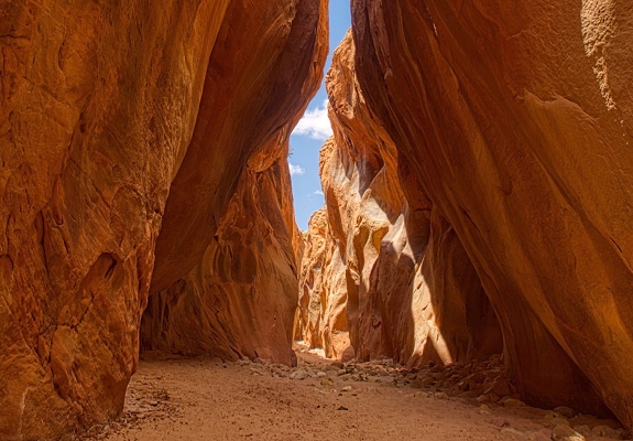
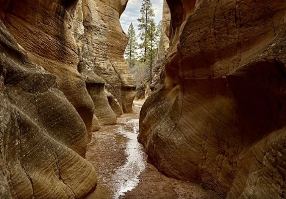
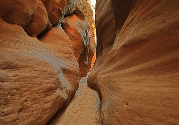
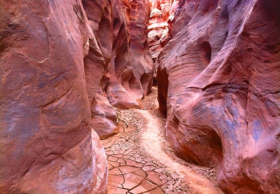
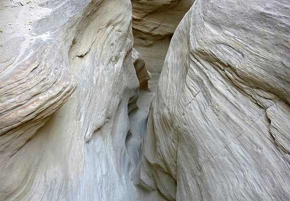
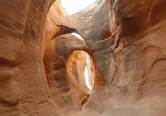
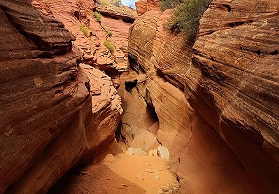
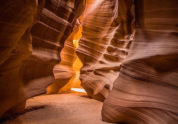
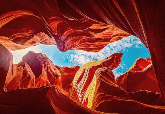
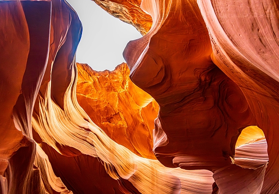
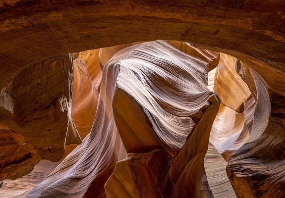
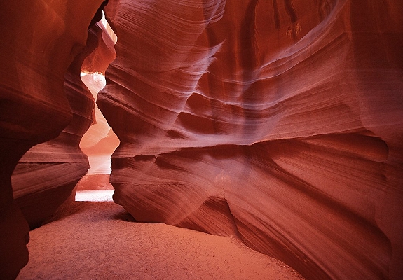
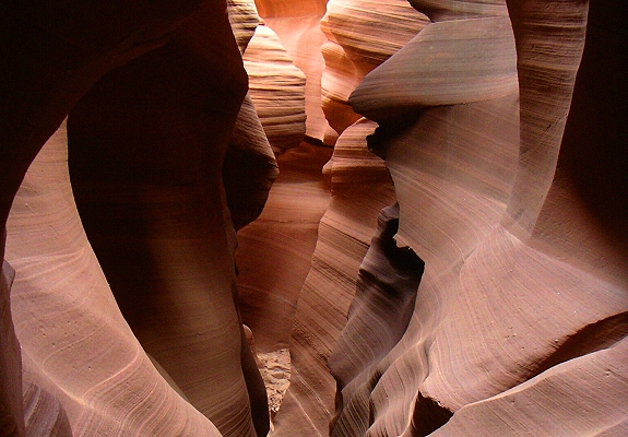
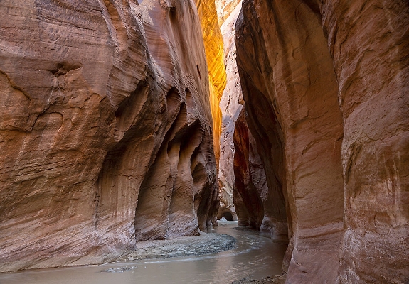
The slot canyons of Utah and Arizona are narrow deep geological formations with sheer vertical walls sculpted by water and wind erosion over a millennia. They are some of the most sought-after destinations for hikers and photographers in the American Southwest due to their vibrant colors, smooth, undulating walls, and dramatic light beams. Slot canyons are formed by the erosive power of flowing water primarily flash floods moving through narrow cracks and fissures in soft sedimentary rock predominantly Navajo Sandstone. They can be incredibly narrow sometimes only inches wide at ground level even as the walls tower hundreds of feet overhead. The constant scouring by water, sand, and debris polishes the sandstone into smooth sinuous curves. The interplay of sunlight filtering down into the deep dark canyons creates spectacular effects and a wide range of red, orange, and purple hues on the canyon walls. The region contains hundreds of slot canyons.
Arizona: The most famous slot canyons are in Arizona many on Navajo Nation land near Page. Antelope Canyon: This is the most famous and photographed slot canyon in the world. It is divided into Upper and Lower Antelope Canyons and access is restricted to guided tours offered by the Navajo Nation. The canyon walls feature flowing smooth shapes and are famous for the light shafts that appear in Upper Antelope Canyon around midday. Buckskin Gulch: As part of the Paria Canyon-Vermilion Cliffs Wilderness, Buckskin Gulch is one of the longest and deepest slot canyons in the United States. It is a challenging multi-day backpacking trip known for its extreme length and risk of flash floods. Waterhole Canyon: Another excellent less crowded option near Page also requiring a guided tour permit from the Navajo Nation.
Utah: A wider variety of accessible and technical slot canyons many within the Grand Staircase-Escalante National Monument: Peekaboo and Spooky Gulches: These are two popular interconnected slot canyons located off the Hole-in-the-Rock Road. Peekaboo requires a short climb to enter and Spooky is extremely narrow making it an adventurous hike for many. Zion National Park: The "Subway" is a world renowned challenging hike known for its distinctive tube-like formation. The Zion Narrows of the Virgin River is another iconic canyon hike through a deep gorge much of it done by wading in the river. Grand Staircase-Escalante National Monument: This vast monument contains a massive network of canyons along the Escalante River and its tributaries offering countless options for canyoneering and hiking.

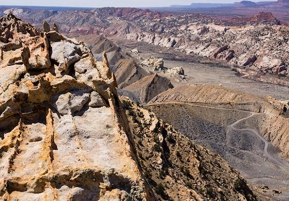
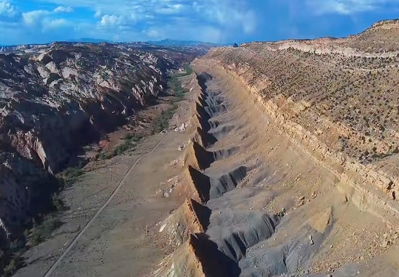
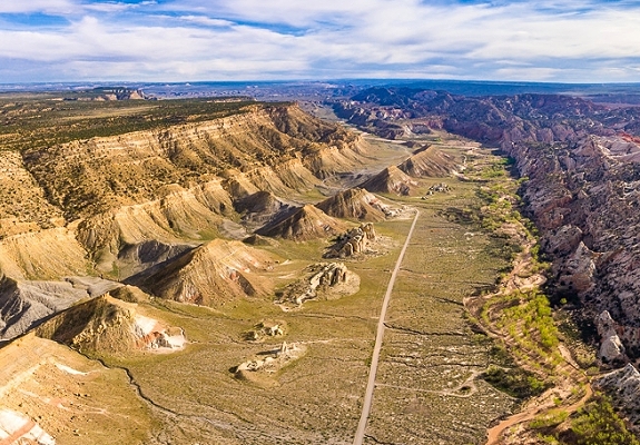
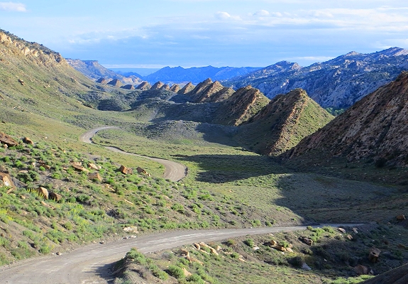
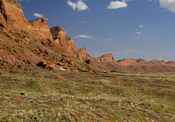
The Cockscomb is a prominent sinuous geologic ridge that runs through southern Utah and northern Arizona forming a defining landmark within the Grand Staircase-Escalante National Monument and the Paria Canyon-Vermilion Cliffs Wilderness. It is known for its dramatic appearance which resembles a rooster's comb due to its jagged steeply angled rock layers. The Cockscomb is the visible surface expression of the East Kaibab Monocline, a major geological fold or flexure that extends for over 100 miles from near Henrieville Utah south through the Grand Canyon to near Flagstaff Arizona. Tectonic Uplift: The monocline was formed during the Laramide orogeny, the mountain-building event that created the Rocky Mountains around 70 to 50 million years ago. Tectonic plate movement caused deep faulting that dramatically tilted the once-horizontal layers of sedimentary rock. Over millions of years wind and water have eroded the softer rock layers leaving behind the more resistant nearly vertical sandstone beds that create the distinctive serrated ridge seen today. The ridge exposes colorful layers of rocks including the Navajo and Entrada Sandstones which show vibrant hues of white, pink, yellow, and red from various mineral pigments. The Cockscomb is a remote and rugged area that offers spectacular, unspoiled scenery.

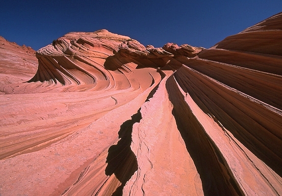
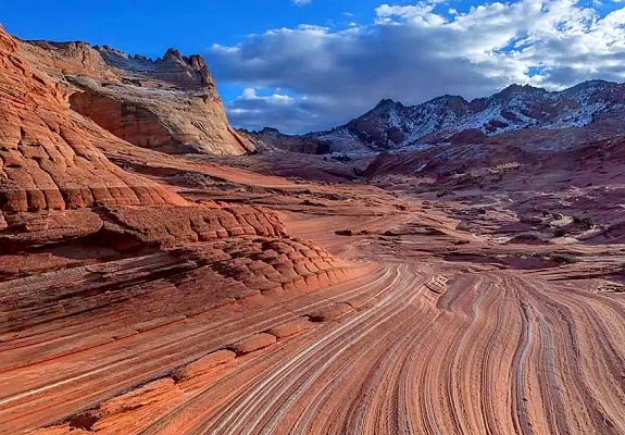
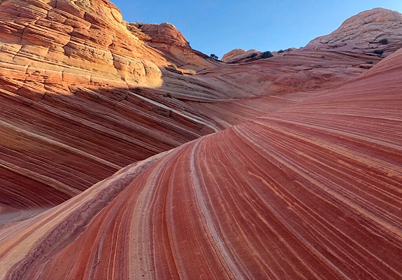
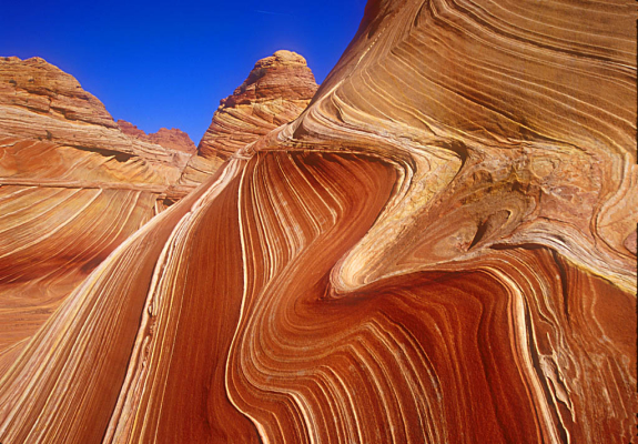
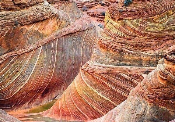
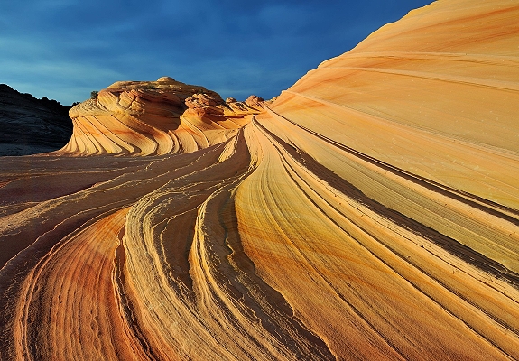
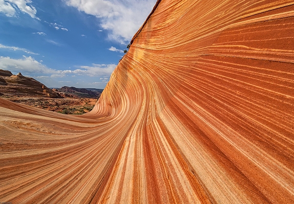
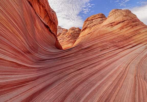
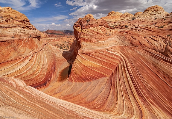
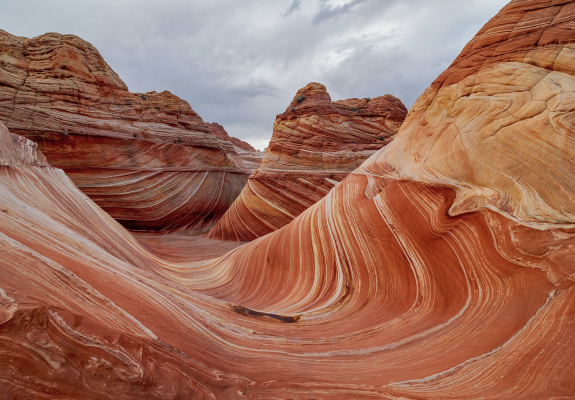
The Wave is a world-renowned sandstone formation located in the North Coyote Buttes area of the Paria Canyon-Vermilion Cliffs Wilderness in extreme northern Arizona close to the Utah border. It is celebrated by hikers and photographers for its striking fluid and undulating shapes that resemble a cresting ocean wave frozen in time. The Wave's stunning appearance is the result of millions of years of geological processes and differential erosion acting on the Jurassic-age Navajo Sandstone. Ancient Dunes: The formation began approximately 190 million years ago as vast desert sand dunes which were then compacted and cemented into rock. The cross-bedded layers within the rock reveal the ancient wind directions from the Jurassic period. Water Erosion: Initially infrequent water runoff carved the U-shaped troughs that form the basic shape of The Wave. Wind Erosion: As the drainage basin shrank wind and blowing sand took over as the primary erosional forces smoothing the canyon walls into their current flowing appearance. Vibrant Colors: The characteristic colors ranging from red, pink, orange, and yellow to white, come from various iron oxide and manganese pigments within the sandstone layers creating the mesmerizing swirling patterns. Due to its incredibly fragile nature and immense popularity, access to The Wave is strictly limited and regulated.


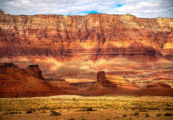
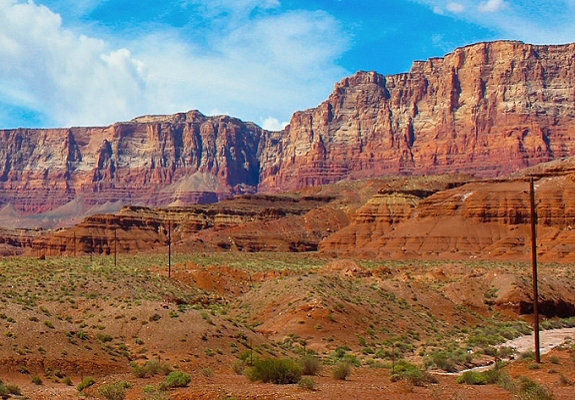
The Vermilion Cliffs are a dramatic 3,000-foot-high escarpment that stretches across northern Arizona and southern Utah forming the second step of the massive Grand Staircase geological formation. Vivid Coloration: The cliffs are aptly named for their striking hues of deep red, orange, and maroon, which blaze in the sunlight and change with the passing light. These colors come from iron oxide and other minerals in the rock layers. Geological History: The cliffs expose hundreds of layers of sedimentary rock primarily the Lower Jurassic Moenave and Kayenta Formations which were deposited in ancient desert dunes, rivers, and floodplains millions of years ago. Tectonic forces later uplifted and tilted these layers and erosion has since sculpted the dramatic escarpment seen today. Remote Wilderness: The area is a designated wilderness known for its solitude and challenging access via unpaved roads many of which require a high-clearance, 4-wheel-drive vehicle, especially after rain or snow. The Vermilion Cliffs area contains some of the American Southwest's most iconic natural wonders. The region is a habitat for diverse wildlife including desert bighorn sheep and a reintroduction site for the endangered California condor which can sometimes be seen soaring above the cliffs.

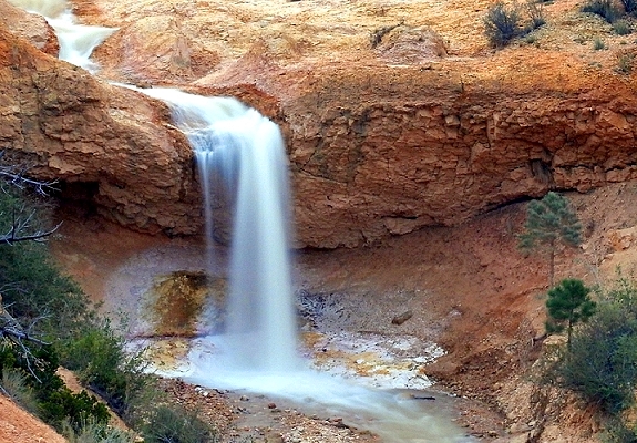
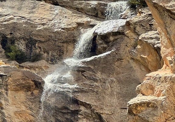
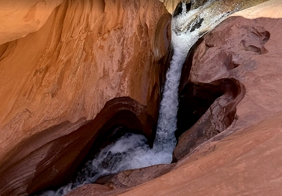
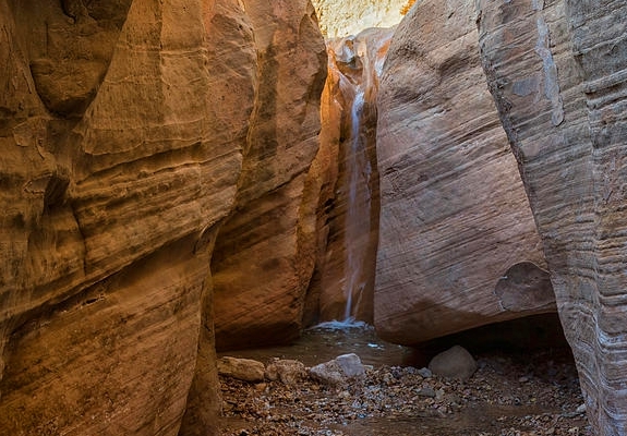
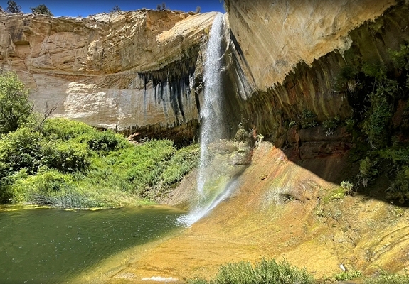
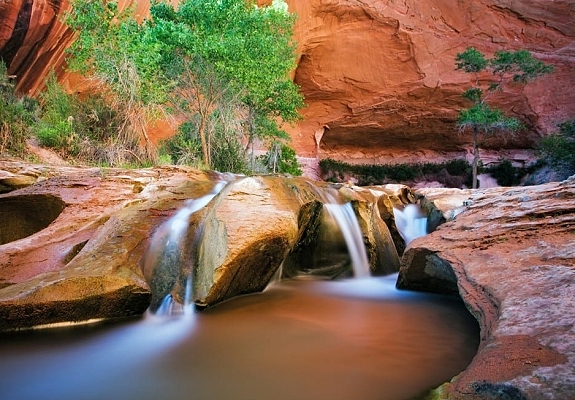
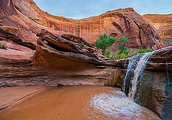
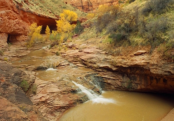
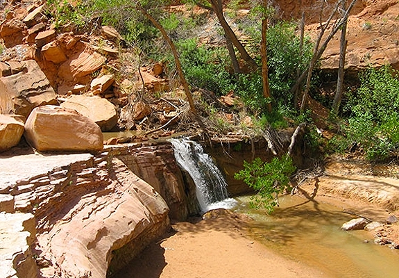
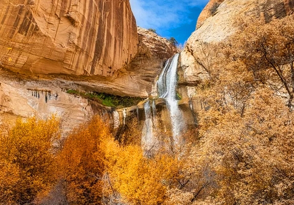
For a desert state Utah has an abundance of beautiful waterfalls. Rushing water is what carved out so many of the cool sandstone formations in the desert but it still seems special to see the water running at full force in this dry environment. Experience a true desert oasis at one of the many incredible waterfalls in southern Utah. The most well-known and accessible waterfalls in the Grand Staircase-Escalante area are the Upper and Lower Calf Creek Falls, both located on perennial Calf Creek in a scenic canyon setting. These waterfalls provide lush year-round oases in the otherwise arid desert landscape and are popular hiking destinations. Lower Calf Creek Falls is the most popular waterfall hike in the monument and is considered a must-see attraction. The falls are a stunning 126-foot cascade that plunges over a sandstone cliff into a large clear pool. The upper falls are a more rugged and secluded option for hikers seeking fewer crowds. The upper tier is an 88-foot plunge waterfall. While the Calf Creek Falls are the main attractions the Escalante Canyons system and its numerous tributaries contain other seasonal or smaller waterfalls that may appear after heavy rains or snowmelt particularly in the spring. These are often found in technical slot canyons or remote backcountry areas.

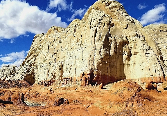
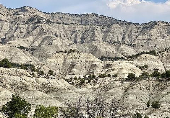
The White Cliffs are a prominent geologic feature of the Grand Staircase in southern Utah. They are a spectacular towering escarpment that stretches for miles and is a central part of the Grand Staircase-Escalante National Monument. The Grand Staircase is a series of five major cliff-and-plateau steps that descend in elevation from Bryce Canyon in the north to the Grand Canyon in the south. The White Cliffs form the third step up from the bottom. Formation: The cliffs are primarily composed of the Navajo Sandstone formation, a massive layer of rock formed from ancient vast desert sand dunes that covered the region around 180 million years ago. Appearance: They are named for their sheer, high, white-to-cream-colored rock faces which can be up to 500 feet high in some areas. The white coloration comes from the lack of iron oxide pigments prevalent in the redder rock layers below. Wind and water erosion have sculpted the sandstone into a variety of forms including massive domes, sheer cliff faces, and unique features like the Wahweap Hoodoos and brain rocks formations in specific remote areas. The White Cliffs are easily viewed from various points within the Grand Staircase-Escalante National Monument and nearby parks. The White Cliffs 3 Province is the most visible formation of Grand Staircase National Monument located at its highest elevation.

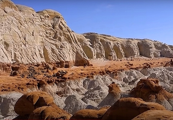
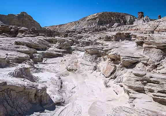

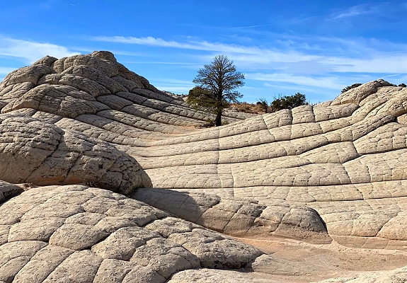
White Pocket is a remote surreal geological wonderland located in the Paria Plateau region of the Vermilion Cliffs National Monument in extreme northern Arizona near the Utah border. The Navajo Sandstone is exposed on the plateau as mounds and ridges. This is one of the places where you might find yourself wondering if you’re still on planet earth. It is renowned for its unique otherworldly sandstone formations and vibrant swirling colors that attract photographers and adventurers seeking solitude. The landscape of White Pocket is composed primarily of the Jurassic-age Navajo Sandstone which originated as ancient desert sand dunes that were later compressed and twisted into rock. The formations are characterized by Brain Rock, Swirling Patterns and Colors The surface of the white layer is often split by a network of deep irregular polygonal cracks. Water Pockets: Shallow depressions in the rock surface can collect rainwater creating temporary pools that offer beautiful reflection photography opportunities. The precise geological process behind these unusual formations is still debated but a leading theory is that soft sediment deformation occurred when the sand was saturated with water before it fully solidified into rock. White Pocket is deliberately kept remote to preserve its delicate environment.


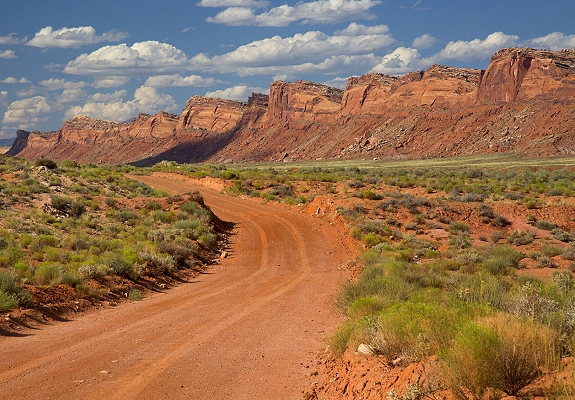
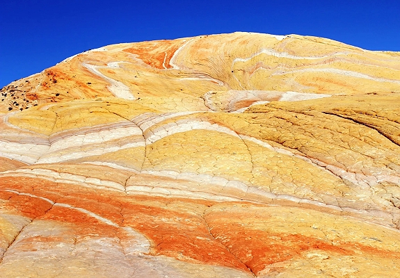
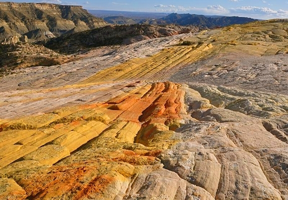
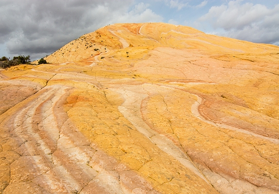
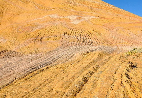
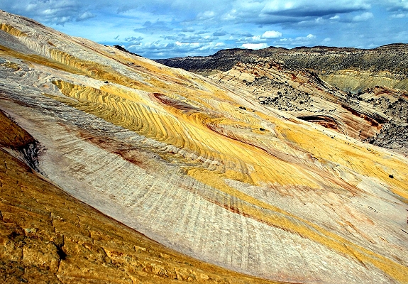
Yellow Rock is a large solitary dome of multicolored slickrock in a remote section of the Grand Staircase-Escalante National Monument in southern Utah known for its unique appearance and panoramic views. It is a popular destination for hikers and photographers due to the unusual almost neo-acrylic swirling patterns and vibrant colors of its sandstone surface. Geology: Yellow Rock is a massive expanse of the Navajo Sandstone formation, a prevalent rock type on the Colorado Plateau. Its distinctive yellow hue comes from the mineral limonite while swirls and bands of orange, red, pink, white, and tan are stains from evaporated mineral-rich water. This diversity of color is the main attraction and the patterns change appearance depending on the light and weather. Unlike typical slickrock areas with abundant canyons or hoodoos Yellow Rock is a large rounded dome with a smoother surface marked by intricate thin-layered ridges and polygonal cracks that create a striking visual effect. It is situated off the unpaved Cottonwood Canyon Road that runs through the monument. The rock itself sits atop a section of The Cockscomb, the jagged, upturned geologic ridge that is part of the East Kaibab Monocline.

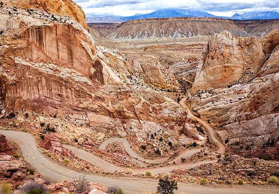
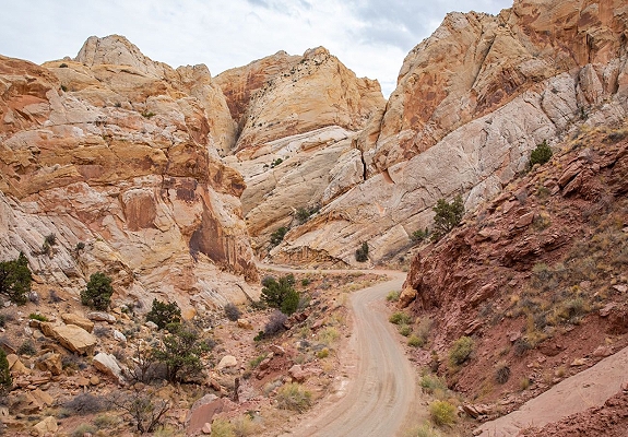
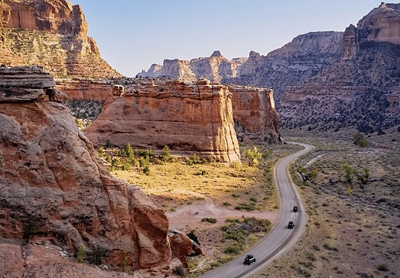
The Burr Trail Road is a 67-mile scenic backway in southern Utah that connects the town of Boulder to the Bullfrog Marina at Lake Powell. Renowned as one of Utah's most picturesque drives, it traverses the Grand Staircase-Escalante National Monument, Capitol Reef National Park, and Glen Canyon National Recreation. The drive is a mix of paved and unpaved surfaces. Paved Section: The first 30 miles from Boulder to the boundary of Capitol Reef National Park are paved and accessible to all passenger vehicles. Unpaved Section: Inside Capitol Reef, the road becomes a graded dirt and gravel surface, including the famous switchbacks. Weather Sensitivity: The dirt sections have high clay content and can become impassable even for 4WD vehicles during or after rain/snow. Restrictions: The steep, narrow switchbacks are strictly unsuitable for RVs or trailers. The route offers dramatic geological transitions and several popular stops. Long Canyon: A spectacular 7-mile stretch where sheer Wingate sandstone walls tower hundreds of feet above the road. Singing Canyon: A short walk from the road into a small slot canyon known for its incredible natural acoustics. Burr Trail Switchbacks: A series of tight turns that descend 800 feet in just half a mile, offering panoramic views of the Waterpocket Fold and the Henry Mountains. Strike Valley Overlook: Accessible via a 4WD spur road (Upper Muley Twist), providing one of the best vistas of the 100-mile long Waterpocket Fold.

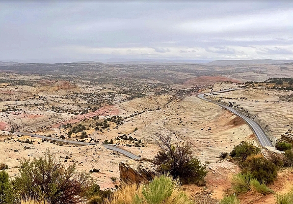
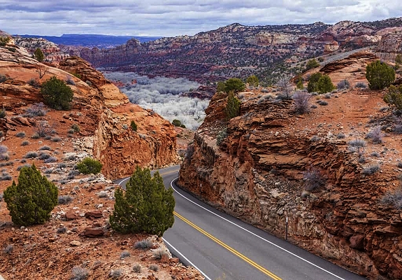
Utah's Scenic Byway 12 is also known as A Journey Through Time and a 124-mile All-American Road connecting Bryce Canyon National Park to Capitol Reef National Park. It is widely considered one of the most beautiful drives in the world. The highway is open year-round, but winter weather currently impacts travel. Road Snow: Significant accumulation of 5–15 inches is possible in winter particularly on the Boulder Mountain stretch (elevation 9,000+ ft), which can become treacherous or temporarily impassable until plowed. Precautions: Traction devices may be required during active storms. Red Canyon: Located at the western end near Panguitch is famous for its brilliant red hoodoos and pine-lined vistas. The Hogsback: A spine-tingling section between Escalante and Boulder where the road traverses a narrow ridge with steep drops on both sides and no guardrails. Access world-class hiking from the road including: Lower Calf Creek Falls: A popular 6-mile round-trip hike to a 126-foot waterfall. Peek-A-Boo & Spooky Slot Canyons: Located off the unpaved Hole-in-the-Rock Road, which intersects Byway 12. Boulder Mountain: The highest point of the drive, offering views that stretch across the Waterpocket Fold to the Henry Mountains. Anasazi State Park Museum: Located in Boulder it preserves an ancient Ancestral Puebloan village. Drive Time: While 124 miles sounds short, allow at least 4–5 hours for driving alone due to steep grades and winding turns.

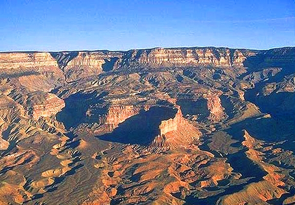
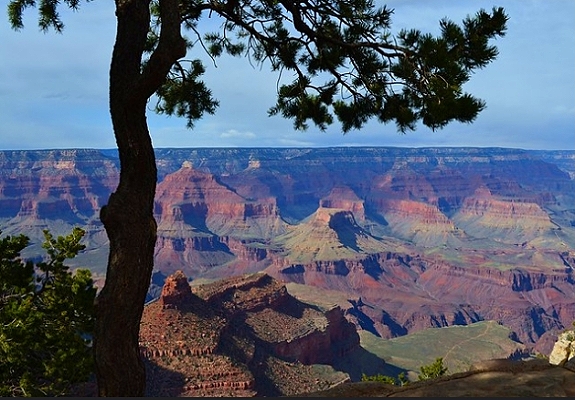
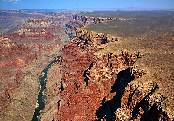
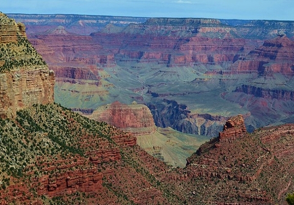
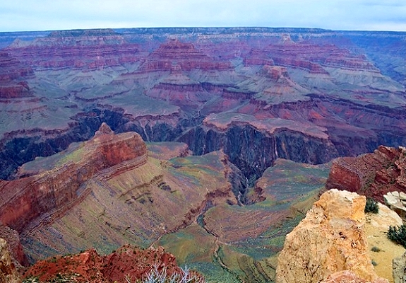
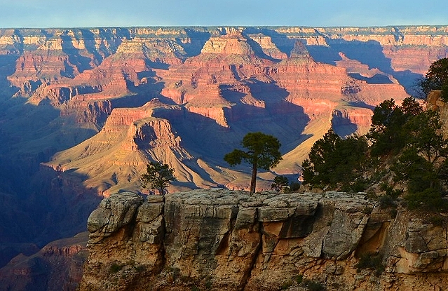
The Grand Canyon is a geologic wonder and ancestral homeland entirely within the state of Arizona. It encompasses 278 miles of the Colorado River and adjacent uplands. The Grand Canyon is one of the most spectacular examples of erosion anywhere in the world. A mile deep canyon unmatched in the incomparable vistas it offers visitors from both north and south rims. Nearly two billion years of Earth's geological history have been exposed as the Colorado River and its tributaries cut their channels through layer after layer of rock while the Colorado Plateau was uplifted. The Grand Canyon lies in the southwestern portion of the Colorado Plateau which occupies a large area of the southwestern United States and consists essentially of horizontal layered rocks and lava flows. The broad intricately sculptured chasm of the canyon contains between its outer walls a multitude of imposing peaks, buttes, gorges, and ravines. The Grand Canyon is a winding course from the joining of the Green River, San Juan River, Paria River, Escalante River to join the Colorado River in Utah and flow into Arizona through the Grand Canyon to the Grand Wash Cliffs near the Nevada state line.

Explore Utah was created and is maintained by Explore Utah Online ©2020-2026 (All Rights Reserved) This website was created for the enjoyment of Utah. If you believe copyrighted work is available on this website in a way that constitutes a copyright infringement please contact me for removal. All rights to the images and other materials used belong to their respective owners. I do not claim ownership over any third-party content used. Grand Staircase Escalante Partners logo used with permission. Photos on this website are used for educational purposes only and used courtesy of: Al Hartmann - Amelia Mun - Andrea Vignali - Annette Ledet - Bill Wimberley - Brian Haddad - Bill Vollmer - Bill Lawrence - Brent Hart - Brigit Grimm - Darwin Moore - Elaine Adams - Eric Liefer - Evan Caldwell - Greg Martinjako - Gregory Bryan - Jeffrey Danneels - John Rihs - James Schumacher - Jacob Struhelka - Jane Vega Escobar - Joe Burris - Karen Monsen - Ken Boie - Lisa Bennett - Leigh McAdam - Laura Rabenberg - Lauren Cernosek - Lisa Gerber - Marc Greenway - Matt Symes - Marie Bernatchez - Mike Reyfman - Mike Keimig - Natalee Fehr - Patty Peinado - Richard Mixon - Sinjin Eberle - Steve Clark - Stuart Hollins - Steve Bard - Scott Densmore - Stacy Laslo - Stephen Griffith - Sylvain Perrin - William Jeffs - Tristan Caubang - Zach Alan
Send your comments or questions to webmaster@exploreutah.online